Randonnée Marche Plan-d'Aups-Sainte-Baume - Test parcours PNR - Photo
 PNR_Ste_Baume
PNR_Ste_Baume

Utilisateur

© OpenStreetMap contributors
Longueur
Longueur
2,6 km
Altitude max
Altitude max
699 m
Dénivelé positif
Dénivelé positif
31 m
Km-Effort
Km-Effort  
3 km
Altitude min
Altitude min
675 m
Dénivelé négatif
Dénivelé négatif
28 m
Boucle
Boucle
Oui
Date de création :
2015-04-09 00:00:00.0
Dernière modification :
2015-04-09 00:00:00.0

(0 Avis)

Marche
Marche
40m
Difficulté : Inconnu

Scannez ce code QR pour ouvrir la randonnée dans l'application SityTrail

Application GPS de randonnée GRATUITE

Logo SityTrail SityTrail

IGN / Instituts géographiques

Télécharger SityTrail sur l'App Store Télécharger SityTrail sur Google Play

Logo SityTrail SityTrail World

Le monde est à vous

Télécharger SityTrail sur l'App Store Télécharger SityTrail sur Google Play Télécharger SityTrail sur Huawei AppGallery

À propos

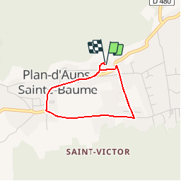
Randonnée Marche de 2,6 km à découvrir à Provence-Alpes-Côte d'Azur, Var, Plan-d'Aups-Sainte-Baume. Cette randonnée est proposée par PNR_Ste_Baume.

Description

Parcours Officiel PNR Sainte-Baume.
Un petit tour dans le Plan d'Aups à partir de la maison du Projet de PNR.


Profil altimétrique

Photos

Points d'intérêt

Point d'intérêt Plan-d'Aups-Sainte-Baume - Maison du futur PNR - Photo
PNR_Ste_Baume
PLAN-D'AUPS-SAINTE-BAUME 
Point d'intérêt Plan-d'Aups-Sainte-Baume - Sitelle - Photo
PNR_Ste_Baume
PLAN-D'AUPS-SAINTE-BAUME 
Point d'intérêt Plan-d'Aups-Sainte-Baume - Borne interactive - Photo
PNR_Ste_Baume
PLAN-D'AUPS-SAINTE-BAUME 
Point d'intérêt Plan-d'Aups-Sainte-Baume - Carrefour - Photo
PNR_Ste_Baume
PLAN-D'AUPS-SAINTE-BAUME 
Point d'intérêt Plan-d'Aups-Sainte-Baume - Maison du Parc - Photo
PNR_Ste_Baume
PLAN-D'AUPS-SAINTE-BAUME 
Point d'intérêt Plan-d'Aups-Sainte-Baume - Restaurant Test - Photo
PNR_Ste_Baume
PLAN-D'AUPS-SAINTE-BAUME 
Point d'intérêt Plan-d'Aups-Sainte-Baume - Chemin privé interdit - Photo
PNR_Ste_Baume
PLAN-D'AUPS-SAINTE-BAUME 
Point d'intérêt Plan-d'Aups-Sainte-Baume - Gouffre - Photo
PNR_Ste_Baume
PLAN-D'AUPS-SAINTE-BAUME 
Point d'intérêt Plan-d'Aups-Sainte-Baume - Descriptif texte - Photo
PNR_Ste_Baume
PLAN-D'AUPS-SAINTE-BAUME 

Localisation

Pays :
France
Région :
Provence-Alpes-Côte d'Azur
Département/Province :
Var
Commune :
Plan-d'Aups-Sainte-Baume
Localité :
Unknown
Départ:(Dec)
Départ:(UTM)
720556 ; 4801158 (31T) N.

Randonnées à proximité

Randonnée Marche Plan-d'Aups-Sainte-Baume - Sainte Baume 8,5 km - Photo
Marche
GUIDE
rvapeldo

Marche

Moyen
(1)
Plan-d'Aups-Sainte-Baume, Provence-Alpes-Côte d'Azur, Var, France
8,4 km | 15,5 km-effort
4h 38min
Oui
Randonnée Marche Plan-d'Aups-Sainte-Baume - Sentier merveilleux - Le paradis - La Grotte Ste Marie Madeleine - Photo
Marche
GUIDE
affinetataille

Marche

Moyen
(1)
Plan-d'Aups-Sainte-Baume, Provence-Alpes-Côte d'Azur, Var, France
15 km | 23 km-effort
6h 0min
Oui
Randonnée Marche Gémenos - dent de roque forcade. cauvin.bertagne. 2 avril 2018 - Photo
Marche
marchev

Marche

Moyen
(1)
Gémenos, Provence-Alpes-Côte d'Azur, Bouches-du-Rhône, France
12,7 km | 20 km-effort
4h 31min
Oui
Randonnée Marche Auriol - la crete des infernets - Photo
Marche
Coryphene

Marche

Difficile
(1)
Auriol, Provence-Alpes-Côte d'Azur, Bouches-du-Rhône, France
8,6 km | 14 km-effort
3h 22min
Oui
Randonnée Marche Plan-d'Aups-Sainte-Baume - Crêts de la Ste Baume - Photo
Marche
tracegps

Marche

Moyen
(2)
Plan-d'Aups-Sainte-Baume, Provence-Alpes-Côte d'Azur, Var, France
15,4 km | 23 km-effort
5h 0min
Oui
Randonnée Marche Gémenos - Autour des Dents de Roque Forcade, Tour de Cauvin - Photo
Marche
tracegps

Marche

Difficile
(1)
Gémenos, Provence-Alpes-Côte d'Azur, Bouches-du-Rhône, France
7,6 km | 11,7 km-effort
3h 15min
Oui
Randonnée Marche Plan-d'Aups-Sainte-Baume - Du Col du Saint-Pilon au Pas de l'Aï, Sainte Baume - Photo
Marche
tracegps

Marche

Moyen
(1)
Plan-d'Aups-Sainte-Baume, Provence-Alpes-Côte d'Azur, Var, France
13,1 km | 20 km-effort
5h 15min
Oui
Randonnée Marche Riboux - Riboux - Forêt de Malaucène - Photo
Marche
tracegps

Marche

Moyen
(4)
Riboux, Provence-Alpes-Côte d'Azur, Var, France
12,2 km | 15,2 km-effort
2h 40min
Oui
Randonnée Marche Plan-d'Aups-Sainte-Baume - La Grotte aux oiseaux - Plan d'Aups  - Photo
Marche
tracegps

Marche

Moyen
(1)
Plan-d'Aups-Sainte-Baume, Provence-Alpes-Côte d'Azur, Var, France
8,8 km | 12,5 km-effort
2h 30min
Oui


Fermer
Mes abonnements