![](/images/other/stat-length.png)
![Randonnée Marche Puget-sur-Argens - z la Lieutenante 7 21-05-24 - Photo](https://media.geolcdn.com/t/1900/400/ext.pjpeg?maxdim=2&url=https%3A%2F%2Fmedia.geolcdn.com%2Ff%2Fd312cfab-1f38-42d3-aa23-092998f9c921.jpg)
z la Lieutenante 7 21-05-24
cb8310
Utilisateur
![Longueur](/images/other/stat-length.png)
Longueur
7,9 km
![Altitude max](https://static1.geolcdn.com/siteimages/upload/files/1508320355ic_sort_altitude_max_24dp.png)
Altitude max
95 m
![Dénivelé positif](https://static1.geolcdn.com/siteimages/upload/files/1508320355ic_sort_den_pos_24dp.png)
Dénivelé positif
81 m
![Km-Effort](/images/other/stat-length.png)
Km-Effort
9 km
![Altitude min](https://static1.geolcdn.com/siteimages/upload/files/1508320355ic_sort_altitude_min_24dp.png)
Altitude min
49 m
![Dénivelé négatif](https://static1.geolcdn.com/siteimages/upload/files/1508320355ic_sort_den_neg_24dp.png)
Dénivelé négatif
82 m
![Boucle](https://static1.geolcdn.com/siteimages/upload/files/16400158638029165_repeat_loop_refresh_sync_direction_icon.png)
Boucle
Oui
Date de création :
2024-05-21 11:53:53.009
Dernière modification :
2024-05-22 09:26:53.507
![Marche](https://static1.geolcdn.com/sitytour/trail-icons/101.png)
2h02
Difficulté : Moyen
![Scannez ce code QR pour ouvrir la randonnée dans l'application SityTrail](https://capi.geolives.com/qq0zvz2zws4bq2lad0pu/sitytour/trails/4062833/qr.png?size=200)
Application GPS de randonnée GRATUITE
À propos
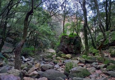
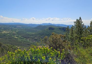
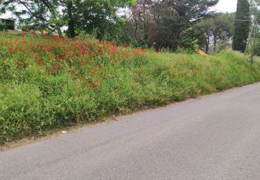
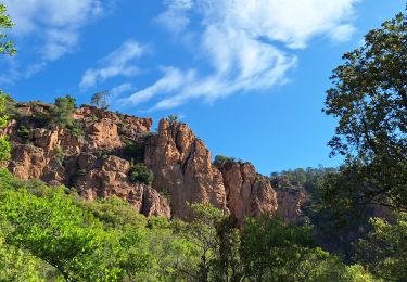
Randonnée Marche de 7,9 km à découvrir à Provence-Alpes-Côte d'Azur, Var, Puget-sur-Argens. Cette randonnée est proposée par cb8310.
Description
rando sans difficultés si ce n'est à 200 m de l'arrivée,le chemin dans les broussailles est barré par un ruisseau que nous ne pouvons pas traverser ;donc demi-tour et retour par une piste qui rallonge le parcours de 2km
Localisation
Pays :
France
Région :
Provence-Alpes-Côte d'Azur
Département/Province :
Var
Commune :
Puget-sur-Argens
Localité :
Unknown
Départ:(Dec)
Départ:(UTM)
313562 ; 4818265 (32T) N.
Commentaires
Randonnées à proximité
![Randonnée V.T.T. Puget-sur-Argens - Forêt de la Colle du Rouet aux Gorges de Blavet - Fréjus - Photo](https://media.geolcdn.com/t/375/260/ext.jpg?maxdim=2&url=https%3A%2F%2Fservices.sitytrail.com%2FGeolivesWS%2FDownloadMedia.ashx%3FTrailID%3D191635%26Media%3D15278_6.jpg)
![V.T.T. V.T.T.](https://static1.geolcdn.com/sitytour/trail-icons/202.png)
Forêt de la Colle du Rouet aux Gorges de Blavet - Fréjus
V.T.T.
Difficile
(1)
Puget-sur-Argens,
Provence-Alpes-Côte d'Azur,
Var,
France
![](/images/other/stat-length.png)
23 km | 28 km-effort
3h 0min
![](https://static1.geolcdn.com/siteimages/upload/files/16400158638029165_repeat_loop_refresh_sync_direction_icon.png)
Oui
![Randonnée Marche Bagnols-en-Forêt - La Colle du Rouet par le Castel Diaou - Le Muy - Photo](https://media.geolcdn.com/t/375/260/ext.jpg?maxdim=2&url=https%3A%2F%2Fservices.sitytrail.com%2FGeolivesWS%2FDownloadMedia.ashx%3FTrailID%3D191579%26Media%3D15205_3.jpg)
![Marche Marche](https://static1.geolcdn.com/sitytour/trail-icons/101.png)
La Colle du Rouet par le Castel Diaou - Le Muy
Marche
Difficile
(2)
Bagnols-en-Forêt,
Provence-Alpes-Côte d'Azur,
Var,
France
![](/images/other/stat-length.png)
18,2 km | 27 km-effort
6h 0min
![](https://static1.geolcdn.com/siteimages/upload/files/16400158638029165_repeat_loop_refresh_sync_direction_icon.png)
Oui
![Randonnée Marche Fréjus - barage du malpasser - Photo](https://media.geolcdn.com/t/375/260/ext.jpg?maxdim=2&url=https%3A%2F%2Fservices.sitytrail.com%2FGeolivesWS%2FDownloadMedia.ashx%3FTrailID%3D232087%26Media%3Dfix__20131111135300.jpg)
![Marche Marche](https://static1.geolcdn.com/sitytour/trail-icons/101.png)
barage du malpasser
Marche
Très facile
(1)
Fréjus,
Provence-Alpes-Côte d'Azur,
Var,
France
![](/images/other/stat-length.png)
5,1 km | 7,6 km-effort
1h 55min
![](https://static1.geolcdn.com/siteimages/upload/files/16400158638029165_repeat_loop_refresh_sync_direction_icon.png)
Oui
![Randonnée A pied Puget-sur-Argens - PUGET SUR ARGENS- gazoduc-Terres Gastes DRI - Photo](https://media.geolcdn.com/t/375/260/ext.jpg?maxdim=2&url=https%3A%2F%2Fstatic1.geolcdn.com%2Fsiteimages%2Fupload%2Ffiles%2F1545311037marcheuse_200dpi.jpg)
![A pied A pied](https://static1.geolcdn.com/sitytour/trail-icons/100.png)
PUGET SUR ARGENS- gazoduc-Terres Gastes DRI
A pied
Facile
(1)
Puget-sur-Argens,
Provence-Alpes-Côte d'Azur,
Var,
France
![](/images/other/stat-length.png)
7,7 km | 8,9 km-effort
2h 1min
![](https://static1.geolcdn.com/siteimages/upload/files/16400158638029165_repeat_loop_refresh_sync_direction_icon.png)
Oui
![Randonnée A pied Bagnols-en-Forêt - BAGNOLS EN FORET- Bois du défens DRI - Photo](https://media.geolcdn.com/t/375/260/ext.jpg?maxdim=2&url=https%3A%2F%2Fstatic1.geolcdn.com%2Fsiteimages%2Fupload%2Ffiles%2F1545311037marcheuse_200dpi.jpg)
![A pied A pied](https://static1.geolcdn.com/sitytour/trail-icons/100.png)
BAGNOLS EN FORET- Bois du défens DRI
A pied
Facile
(2)
Bagnols-en-Forêt,
Provence-Alpes-Côte d'Azur,
Var,
France
![](/images/other/stat-length.png)
9,3 km | 12,7 km-effort
2h 52min
![](https://static1.geolcdn.com/siteimages/upload/files/16400158638029165_repeat_loop_refresh_sync_direction_icon.png)
Oui
![Randonnée Marche Bagnols-en-Forêt - Gorges du Blavet au col de la pierre du coucou - Photo](https://media.geolcdn.com/t/375/260/ext.jpg?maxdim=2&url=https%3A%2F%2Fmedia.geolcdn.com%2Ff%2F09e580ef-d921-4dee-80f6-a698afe27096.jpg)
![Marche Marche](https://static1.geolcdn.com/sitytour/trail-icons/101.png)
Gorges du Blavet au col de la pierre du coucou
Marche
Difficile
Bagnols-en-Forêt,
Provence-Alpes-Côte d'Azur,
Var,
France
![](/images/other/stat-length.png)
15,8 km | 22 km-effort
4h 44min
![](https://static1.geolcdn.com/siteimages/upload/files/16400158638029165_repeat_loop_refresh_sync_direction_icon.png)
Oui
![Randonnée Marche Bagnols-en-Forêt - Gorges du Blavet - Photo](https://media.geolcdn.com/t/375/260/ext.jpg?maxdim=2&url=https%3A%2F%2Fmedia.geolcdn.com%2Ff%2Ff64ac804-86fa-483d-a3a0-c10a6b29b92b.jpg)
![Marche Marche](https://static1.geolcdn.com/sitytour/trail-icons/101.png)
Gorges du Blavet
Marche
Facile
Bagnols-en-Forêt,
Provence-Alpes-Côte d'Azur,
Var,
France
![](/images/other/stat-length.png)
11,3 km | 18,6 km-effort
5h 0min
![](https://static1.geolcdn.com/siteimages/upload/files/16400158638029165_repeat_loop_refresh_sync_direction_icon.png)
Oui
![Randonnée Marche Roquebrune-sur-Argens - Tour du lac de l'arèna - Photo](https://media.geolcdn.com/t/375/260/ext.jpg?maxdim=2&url=https%3A%2F%2Fmedia.geolcdn.com%2Ff%2Fc06de7cb-679d-477f-a3bc-96dd730644f2.jpg)
![Marche Marche](https://static1.geolcdn.com/sitytour/trail-icons/101.png)
Tour du lac de l'arèna
Marche
Facile
Roquebrune-sur-Argens,
Provence-Alpes-Côte d'Azur,
Var,
France
![](/images/other/stat-length.png)
3,7 km | 4 km-effort
56min
![](https://static1.geolcdn.com/siteimages/upload/files/16400158638029165_repeat_loop_refresh_sync_direction_icon.png)
Oui
![Randonnée Marche Roquebrune-sur-Argens - La Bouverie - Gorges du Blavet - Grotte du Muéron - Photo](https://media.geolcdn.com/t/375/260/ext.jpg?maxdim=2&url=https%3A%2F%2Fmedia.geolcdn.com%2Ff%2F867aec0a-5e80-4bc3-a435-de9966de7428.jpg)
![Marche Marche](https://static1.geolcdn.com/sitytour/trail-icons/101.png)
La Bouverie - Gorges du Blavet - Grotte du Muéron
Marche
Facile
Roquebrune-sur-Argens,
Provence-Alpes-Côte d'Azur,
Var,
France
![](/images/other/stat-length.png)
7,9 km | 11,3 km-effort
2h 27min
![](https://static1.geolcdn.com/siteimages/upload/files/16400158638029165_repeat_loop_refresh_sync_direction_icon.png)
Oui