


20240601 ""xxxxx"

Jeanclaudebic
Utilisateur
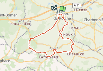

Longueur
15,6 km

Altitude max
255 m

Dénivelé positif
205 m
Km-Effort
18,4 km

Altitude min
180 m

Dénivelé négatif
207 m
Boucle
Oui
Date de création :
2024-06-01 15:33:51.927
Dernière modification :
2024-06-01 19:38:46.97
4h04
Difficulté : Difficile

Application GPS de randonnée GRATUITE
 SityTrail
IGN / Instituts géographiques
SityTrail Plus
Le monde est à vous
À propos
Randonnée Marche de 15,6 km à découvrir à Centre-Val de Loire, Eure-et-Loir, Authon-du-Perche. Cette randonnée est proposée par Jeanclaudebic.
Localisation
Pays :
France
Région :
Centre-Val de Loire
Département/Province :
Eure-et-Loir
Commune :
Authon-du-Perche
Localité :
Authon-du-Perche
Départ:(Dec)
Départ:(UTM)
343216 ; 5340234 (31U) N.
Commentaires