


Chemin Amadour jour 2

Evelyne Bouchereau
Utilisateur
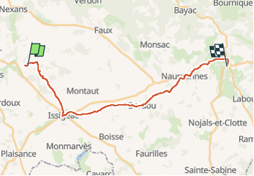

Longueur
24 km

Altitude max
177 m

Dénivelé positif
321 m
Km-Effort
28 km

Altitude min
69 m

Dénivelé négatif
296 m
Boucle
Non
Date de création :
2024-06-12 06:40:25.708
Dernière modification :
2024-06-12 14:00:14.124
5h18
Difficulté : Très difficile

Application GPS de randonnée GRATUITE
 SityTrail
IGN / Instituts géographiques
SityTrail Plus
Le monde est à vous
À propos
Randonnée Marche de 24 km à découvrir à Nouvelle-Aquitaine, Dordogne, Saint-Cernin-de-Labarde. Cette randonnée est proposée par Evelyne Bouchereau.
Localisation
Pays :
France
Région :
Nouvelle-Aquitaine
Département/Province :
Dordogne
Commune :
Saint-Cernin-de-Labarde
Localité :
Unknown
Départ:(Dec)
Départ:(UTM)
307871 ; 4959678 (31T) N.
Commentaires