


Hohnstein cap

LauVan
Utilisateur
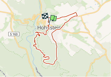

Longueur
8 km

Altitude max
363 m

Dénivelé positif
204 m
Km-Effort
10,6 km

Altitude min
247 m

Dénivelé négatif
189 m
Boucle
Oui
Date de création :
2024-07-23 13:56:41.979
Dernière modification :
2024-07-23 14:45:41.392
48m
Difficulté : Facile

Application GPS de randonnée GRATUITE
 SityTrail
IGN / Instituts géographiques
SityTrail Plus
Le monde est à vous
À propos
Randonnée Course à pied de 8 km à découvrir à Saxe, Sächsische Schweiz-Osterzgebirge, Hohnstein. Cette randonnée est proposée par LauVan.
Localisation
Pays :
Allemagne
Région :
Saxe
Département/Province :
Sächsische Schweiz-Osterzgebirge
Commune :
Hohnstein
Localité :
Unknown
Départ:(Dec)
Départ:(UTM)
437594 ; 5648039 (33U) N.
Commentaires