


Halspelschiedt Roppeviller Colorado

sgazaix
Utilisateur
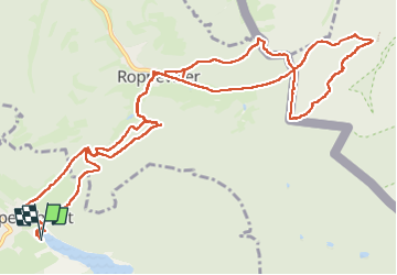

Longueur
15,2 km

Altitude max
408 m

Dénivelé positif
457 m
Km-Effort
21 km

Altitude min
269 m

Dénivelé négatif
456 m
Boucle
Oui
Date de création :
2024-07-28 07:57:43.455
Dernière modification :
2024-07-28 12:26:20.728
3h32
Difficulté : Facile

Application GPS de randonnée GRATUITE
 SityTrail
IGN / Instituts géographiques
SityTrail Plus
Le monde est à vous
À propos
Randonnée Marche de 15,2 km à découvrir à Grand Est, Moselle, Haspelschiedt. Cette randonnée est proposée par sgazaix.
Description
pas trop d'aller-retour
Localisation
Pays :
France
Région :
Grand Est
Département/Province :
Moselle
Commune :
Haspelschiedt
Localité :
Unknown
Départ:(Dec)
Départ:(UTM)
389751 ; 5437996 (32U) N.
Commentaires