


SityTrail - Aix en Othe St Mards en othe et les hameaux

fasbi67
Utilisateur
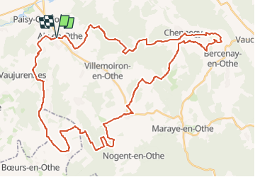

Longueur
54 km

Altitude max
254 m

Dénivelé positif
904 m
Km-Effort
66 km

Altitude min
130 m

Dénivelé négatif
903 m
Boucle
Oui
Date de création :
2024-08-21 19:33:54.471
Dernière modification :
2024-08-21 19:35:07.625

Application GPS de randonnée GRATUITE
 SityTrail
IGN / Instituts géographiques
SityTrail Plus
Le monde est à vous
À propos
Randonnée de 54 km à découvrir à Grand Est, Aube, Aix-Villemaur-Pâlis. Cette randonnée est proposée par fasbi67.
Localisation
Pays :
France
Région :
Grand Est
Département/Province :
Aube
Commune :
Aix-Villemaur-Pâlis
Localité :
Aix-en-Othe
Départ:(Dec)
Départ:(UTM)
554284 ; 5341234 (31U) N.
Commentaires