


schef

jcschubnel
Utilisateur
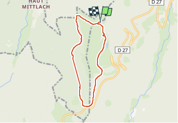

Longueur
6,2 km

Altitude max
1201 m

Dénivelé positif
192 m
Km-Effort
8,8 km

Altitude min
1038 m

Dénivelé négatif
196 m
Boucle
Oui
Date de création :
2024-06-23 07:12:51.44
Dernière modification :
2024-08-31 14:24:18.761
1h40
Difficulté : Moyen

Application GPS de randonnée GRATUITE
 SityTrail
IGN / Instituts géographiques
SityTrail Plus
Le monde est à vous
À propos
Randonnée Marche de 6,2 km à découvrir à Grand Est, Haut-Rhin, Sondernach. Cette randonnée est proposée par jcschubnel.
Localisation
Pays :
France
Région :
Grand Est
Département/Province :
Haut-Rhin
Commune :
Sondernach
Localité :
Unknown
Départ:(Dec)
Départ:(UTM)
354271 ; 5316977 (32T) N.
Commentaires