


Hanches Gas 11km

topophil
Utilisateur
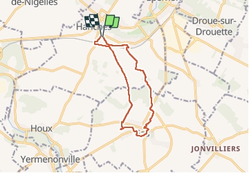

Longueur
11,1 km

Altitude max
163 m

Dénivelé positif
110 m
Km-Effort
12,5 km

Altitude min
117 m

Dénivelé négatif
109 m
Boucle
Oui
Date de création :
2024-09-11 07:15:15.891
Dernière modification :
2024-09-11 10:10:25.147
2h54
Difficulté : Difficile

Application GPS de randonnée GRATUITE
 SityTrail
IGN / Instituts géographiques
SityTrail Plus
Le monde est à vous
À propos
Randonnée Marche de 11,1 km à découvrir à Centre-Val de Loire, Eure-et-Loir, Hanches. Cette randonnée est proposée par topophil.
Localisation
Pays :
France
Région :
Centre-Val de Loire
Département/Province :
Eure-et-Loir
Commune :
Hanches
Localité :
Unknown
Départ:(Dec)
Départ:(UTM)
400236 ; 5383551 (31U) N.
Commentaires