


ALBARET 28 km VTT St Juéry

benoit48
Utilisateur
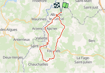

Longueur
28 km

Altitude max
1125 m

Dénivelé positif
637 m
Km-Effort
37 km

Altitude min
927 m

Dénivelé négatif
635 m
Boucle
Oui
Date de création :
2018-01-06 00:00:00.0
Dernière modification :
2018-01-06 00:00:00.0
2h00
Difficulté : Facile

Application GPS de randonnée GRATUITE
 SityTrail
IGN / Instituts géographiques
SityTrail Plus
Le monde est à vous
À propos
Randonnée V.T.T. de 28 km à découvrir à Occitanie, Lozère, Albaret-le-Comtal. Cette randonnée est proposée par benoit48.
Description
Albaret > Mortesagne > Volpière > Fournels > Fauge > Genestuéjols > St Juéry > Le Mazel > Courbepeyre > Arzenc d'apacher > Le Villaret > Albaret
Localisation
Pays :
France
Région :
Occitanie
Département/Province :
Lozère
Commune :
Albaret-le-Comtal
Localité :
Unknown
Départ:(Dec)
Départ:(UTM)
510911 ; 4969998 (31T) N.
Commentaires