


Randonnée

pierreliben
Utilisateur
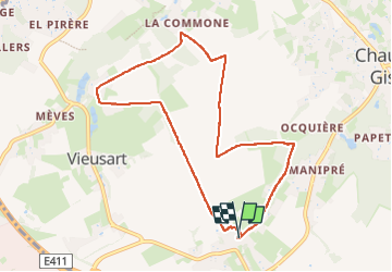

Longueur
8 km

Altitude max
132 m

Dénivelé positif
100 m
Km-Effort
9,3 km

Altitude min
92 m

Dénivelé négatif
101 m
Boucle
Oui
Date de création :
2024-10-06 10:45:14.0
Dernière modification :
2024-10-06 12:17:01.607
1h30
Difficulté : Très facile

Application GPS de randonnée GRATUITE
 SityTrail
IGN / Instituts géographiques
SityTrail Plus
Le monde est à vous
À propos
Randonnée Marche de 8 km à découvrir à Wallonie, Brabant wallon, Chaumont-Gistoux. Cette randonnée est proposée par pierreliben.

Localisation
Pays :
Belgique
Région :
Wallonie
Département/Province :
Brabant wallon
Commune :
Chaumont-Gistoux
Localité :
Unknown
Départ:(Dec)
Départ:(UTM)
618131 ; 5614099 (31U) N.
Commentaires