


dambach ortenbourg

anniston
Utilisateur
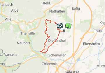

Longueur
23 km

Altitude max
654 m

Dénivelé positif
685 m
Km-Effort
32 km

Altitude min
186 m

Dénivelé négatif
685 m
Boucle
Oui
Date de création :
2024-10-20 08:24:54.385
Dernière modification :
2025-01-16 11:02:32.369
4h16
Difficulté : Difficile

Application GPS de randonnée GRATUITE
 SityTrail
IGN / Instituts géographiques
SityTrail Plus
Le monde est à vous
À propos
Randonnée Randonnée équestre de 23 km à découvrir à Grand Est, Bas-Rhin, Dambach-la-Ville. Cette randonnée est proposée par anniston.
Description
Ne pas prendre le sentier rond rouge entre l'Ortenbourg et la Huenelmuhl, sentier très difficile à cheval (escaliers et rochers)
Localisation
Pays :
France
Région :
Grand Est
Département/Province :
Bas-Rhin
Commune :
Dambach-la-Ville
Localité :
Unknown
Départ:(Dec)
Départ:(UTM)
384052 ; 5353284 (32U) N.
Commentaires