


Sentheim Saegenkopf Hutte

Alain28/01
Utilisateur
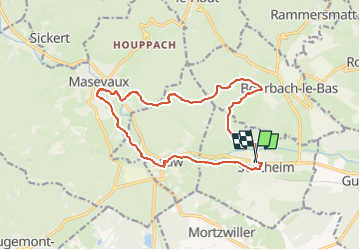

Longueur
14,5 km

Altitude max
534 m

Dénivelé positif
278 m
Km-Effort
18,2 km

Altitude min
353 m

Dénivelé négatif
278 m
Boucle
Oui
Date de création :
2024-11-16 17:11:59.0
Dernière modification :
2024-11-16 17:13:23.741
4h08
Difficulté : Facile

Application GPS de randonnée GRATUITE
 SityTrail
IGN / Instituts géographiques
SityTrail Plus
Le monde est à vous
À propos
Randonnée A pied de 14,5 km à découvrir à Grand Est, Haut-Rhin, Sentheim. Cette randonnée est proposée par Alain28/01.
Localisation
Pays :
France
Région :
Grand Est
Département/Province :
Haut-Rhin
Commune :
Sentheim
Localité :
Unknown
Départ:(Dec)
Départ:(UTM)
353796 ; 5291037 (32T) N.
Commentaires