


Rando AixVTT 2018 - 30 km - 500 D+ Arbois

Alain Derrives
Utilisateur
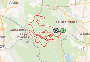

Longueur
26 km

Altitude max
268 m

Dénivelé positif
423 m
Km-Effort
31 km

Altitude min
121 m

Dénivelé négatif
421 m
Boucle
Oui
Date de création :
2024-11-27 22:26:06.55
Dernière modification :
2025-04-19 14:47:11.027
2h10
Difficulté : Difficile

Application GPS de randonnée GRATUITE
 SityTrail
IGN / Instituts géographiques
SityTrail Plus
Le monde est à vous
À propos
Randonnée V.T.T. de 26 km à découvrir à Provence-Alpes-Côte d'Azur, Bouches-du-Rhône, Aix-en-Provence. Cette randonnée est proposée par Alain Derrives.
Localisation
Pays :
France
Région :
Provence-Alpes-Côte d'Azur
Département/Province :
Bouches-du-Rhône
Commune :
Aix-en-Provence
Localité :
Unknown
Départ:(Dec)
Départ:(UTM)
687390 ; 4817622 (31T) N.
Commentaires