


Allan - Aiguebelle

randochu
Utilisateur
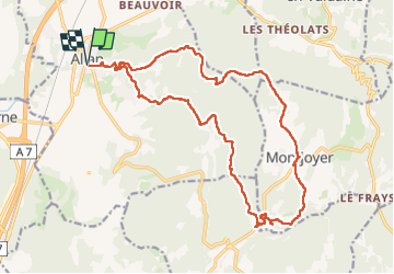

Longueur
22 km

Altitude max
408 m

Dénivelé positif
567 m
Km-Effort
30 km

Altitude min
150 m

Dénivelé négatif
568 m
Boucle
Oui
Date de création :
2025-02-14 08:04:14.731
Dernière modification :
2025-02-15 06:26:19.407
5h52
Difficulté : Moyen

Application GPS de randonnée GRATUITE
 SityTrail
IGN / Instituts géographiques
SityTrail Plus
Le monde est à vous
À propos
Randonnée Marche de 22 km à découvrir à Auvergne-Rhône-Alpes, Drôme, Allan. Cette randonnée est proposée par randochu.
Localisation
Pays :
France
Région :
Auvergne-Rhône-Alpes
Département/Province :
Drôme
Commune :
Allan
Localité :
Unknown
Départ:(Dec)
Départ:(UTM)
642078 ; 4928760 (31T) N.
Commentaires