


20240319 xxxxvvv

Jeanclaudebic
Utilisateur
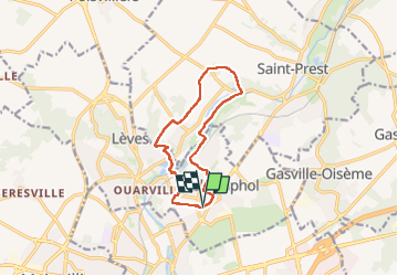

Longueur
10,4 km

Altitude max
158 m

Dénivelé positif
119 m
Km-Effort
12 km

Altitude min
116 m

Dénivelé négatif
118 m
Boucle
Oui
Date de création :
2025-03-19 12:59:08.622
Dernière modification :
2025-03-19 15:06:55.277
2h07
Difficulté : Moyen

Application GPS de randonnée GRATUITE
 SityTrail
IGN / Instituts géographiques
SityTrail Plus
Le monde est à vous
À propos
Randonnée Marche de 10,4 km à découvrir à Centre-Val de Loire, Eure-et-Loir, Champhol. Cette randonnée est proposée par Jeanclaudebic.
Localisation
Pays :
France
Région :
Centre-Val de Loire
Département/Province :
Eure-et-Loir
Commune :
Champhol
Localité :
Unknown
Départ:(Dec)
Départ:(UTM)
389219 ; 5368948 (31U) N.
Commentaires