


20250322 Anet

Jeanclaudebic
Utilisateur
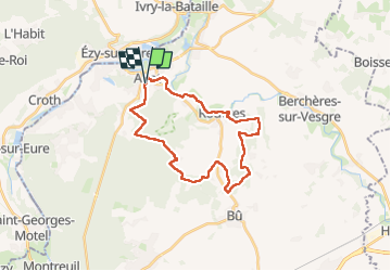

Longueur
25 km

Altitude max
143 m

Dénivelé positif
309 m
Km-Effort
29 km

Altitude min
65 m

Dénivelé négatif
311 m
Boucle
Oui
Date de création :
2025-03-22 07:41:14.17
Dernière modification :
2025-03-22 15:09:11.548
7h27
Difficulté : Très difficile

Application GPS de randonnée GRATUITE
 SityTrail
IGN / Instituts géographiques
SityTrail Plus
Le monde est à vous
À propos
Randonnée Marche de 25 km à découvrir à Centre-Val de Loire, Eure-et-Loir, Anet. Cette randonnée est proposée par Jeanclaudebic.
Description
net
Localisation
Pays :
France
Région :
Centre-Val de Loire
Département/Province :
Eure-et-Loir
Commune :
Anet
Localité :
Unknown
Départ:(Dec)
Départ:(UTM)
385463 ; 5412284 (31U) N.
Commentaires