![](/images/other/stat-length.png)
![Randonnée Marche Joinville-le-Pont - Bords de Marne 02 - Joinville à Chenèvrière - Photo](https://media.geolcdn.com/t/1900/400/ext.pjpeg?maxdim=2&url=https%3A%2F%2Fstatic1.geolcdn.com%2Fsiteimages%2Fupload%2Ffiles%2F1553511878bg_sport_marche.png)
Bords de Marne 02 - Joinville à Chenèvrière
uru2010
Utilisateur
![Longueur](/images/other/stat-length.png)
Longueur
7 km
![Altitude max](https://static1.geolcdn.com/siteimages/upload/files/1508320355ic_sort_altitude_max_24dp.png)
Altitude max
41 m
![Dénivelé positif](https://static1.geolcdn.com/siteimages/upload/files/1508320355ic_sort_den_pos_24dp.png)
Dénivelé positif
38 m
![Km-Effort](/images/other/stat-length.png)
Km-Effort
7,5 km
![Altitude min](https://static1.geolcdn.com/siteimages/upload/files/1508320355ic_sort_altitude_min_24dp.png)
Altitude min
33 m
![Dénivelé négatif](https://static1.geolcdn.com/siteimages/upload/files/1508320355ic_sort_den_neg_24dp.png)
Dénivelé négatif
36 m
![Boucle](https://static1.geolcdn.com/siteimages/upload/files/16400158638029165_repeat_loop_refresh_sync_direction_icon.png)
Boucle
Non
Date de création :
2015-07-08 00:00:00.0
Dernière modification :
2015-07-08 00:00:00.0
![Marche](https://static1.geolcdn.com/sitytour/trail-icons/101.png)
2h41
Difficulté : Facile
![Scannez ce code QR pour ouvrir la randonnée dans l'application SityTrail](https://capi.geolives.com/qq0zvz2zws4bq2lad0pu/sitytour/trails/442158/qr.png?size=200)
Application GPS de randonnée GRATUITE
À propos
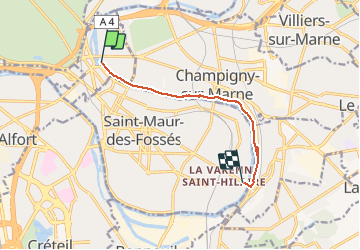
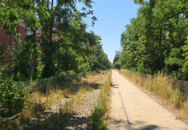
Randonnée Marche de 7 km à découvrir à Île-de-France, Val-de-Marne, Joinville-le-Pont. Cette randonnée est proposée par uru2010.
Description
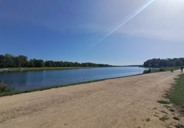
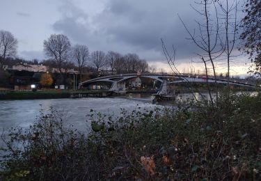
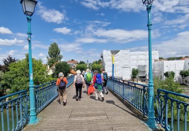
Parcours sympa le long de la Marne, sur la demie-boucle du méandre de la Marne à Joinville.
Malheureusement, arrivé au milieu de la boucle, il n'est pas possible de poursuivre le long de la Marne, il n'y a plus de chemin !
Localisation
Pays :
France
Région :
Île-de-France
Département/Province :
Val-de-Marne
Commune :
Joinville-le-Pont
Localité :
Unknown
Départ:(Dec)
Départ:(UTM)
461145 ; 5407433 (31U) N.
Commentaires
Randonnées à proximité
![Randonnée Marche Neuilly-Plaisance - Neuilly Plaisance gare Rer sortie Bords de Marne/ Base Nautique Vaires sur Marne - Photo](https://media.geolcdn.com/t/375/260/ext.jpg?maxdim=2&url=https%3A%2F%2Fmedia.geolcdn.com%2Ff%2F3fb9e5a2-0030-4f1a-a960-e880d0c7625d.jpg)
![Marche Marche](https://static1.geolcdn.com/sitytour/trail-icons/101.png)
Neuilly Plaisance gare Rer sortie Bords de Marne/ Base Nautique Vaires sur Marne
Marche
Facile
(1)
Neuilly-Plaisance,
Île-de-France,
Seine-Saint-Denis,
France
![](/images/other/stat-length.png)
15,9 km | 17,1 km-effort
2h 52min
![](https://static1.geolcdn.com/siteimages/upload/files/16400158638029165_repeat_loop_refresh_sync_direction_icon.png)
Oui
![Randonnée Marche Paris - DP75-07 De Maraîchers au carrefour Daumesnil - Hecto-Malot - Photo](https://media.geolcdn.com/t/375/260/ext.jpg?maxdim=2&url=https%3A%2F%2Fmedia.geolcdn.com%2Ff%2Ff01e2afd-b4ca-46d4-a57e-1d08cf143cbf.jpg)
![Marche Marche](https://static1.geolcdn.com/sitytour/trail-icons/101.png)
DP75-07 De Maraîchers au carrefour Daumesnil - Hecto-Malot
Marche
Facile
(1)
Paris,
Île-de-France,
Paris,
France
![](/images/other/stat-length.png)
4,8 km | 5,4 km-effort
1h 13min
![](https://static1.geolcdn.com/siteimages/upload/files/16400158638029165_repeat_loop_refresh_sync_direction_icon.png)
Non
![Randonnée A pied Créteil - JC 84 - La Végétale - 18,2 km - Photo](https://media.geolcdn.com/t/375/260/ext.jpg?maxdim=2&url=https%3A%2F%2Fstatic1.geolcdn.com%2Fsiteimages%2Fupload%2Ffiles%2F1545311037marcheuse_200dpi.jpg)
![A pied A pied](https://static1.geolcdn.com/sitytour/trail-icons/100.png)
JC 84 - La Végétale - 18,2 km
A pied
Difficile
(1)
Créteil,
Île-de-France,
Val-de-Marne,
France
![](/images/other/stat-length.png)
18,3 km | 21 km-effort
4h 40min
![](https://static1.geolcdn.com/siteimages/upload/files/16400158638029165_repeat_loop_refresh_sync_direction_icon.png)
Non
![Randonnée Marche Nogent-sur-Marne - Autour des Minimes - Photo](https://media.geolcdn.com/t/375/260/ext.jpg?maxdim=2&url=https%3A%2F%2Fstatic1.geolcdn.com%2Fsiteimages%2Fupload%2Ffiles%2F1553511878bg_sport_marche.png)
![Marche Marche](https://static1.geolcdn.com/sitytour/trail-icons/101.png)
Autour des Minimes
Marche
Très facile
(2)
Nogent-sur-Marne,
Île-de-France,
Val-de-Marne,
France
![](/images/other/stat-length.png)
3,7 km | 4,1 km-effort
53min
![](https://static1.geolcdn.com/siteimages/upload/files/16400158638029165_repeat_loop_refresh_sync_direction_icon.png)
Oui
![Randonnée V.T.T. Fontenay-sous-Bois - vtt bois de vincennes - Photo](https://media.geolcdn.com/t/375/260/ext.jpg?maxdim=2&url=https%3A%2F%2Fstatic1.geolcdn.com%2Fsiteimages%2Fupload%2Ffiles%2F1524743154velo.jpg)
![V.T.T. V.T.T.](https://static1.geolcdn.com/sitytour/trail-icons/202.png)
vtt bois de vincennes
V.T.T.
Moyen
(1)
Fontenay-sous-Bois,
Île-de-France,
Val-de-Marne,
France
![](/images/other/stat-length.png)
38 km | 42 km-effort
1h 59min
![](https://static1.geolcdn.com/siteimages/upload/files/16400158638029165_repeat_loop_refresh_sync_direction_icon.png)
Oui
![Randonnée Marche Saint-Maur-des-Fossés - Boucle de la Marne Saint MAUR des Fosses - Photo](https://media.geolcdn.com/t/375/260/ext.jpg?maxdim=2&url=https%3A%2F%2Fstatic1.geolcdn.com%2Fsiteimages%2Fupload%2Ffiles%2F1553511878bg_sport_marche.png)
![Marche Marche](https://static1.geolcdn.com/sitytour/trail-icons/101.png)
Boucle de la Marne Saint MAUR des Fosses
Marche
Facile
(2)
Saint-Maur-des-Fossés,
Île-de-France,
Val-de-Marne,
France
![](/images/other/stat-length.png)
13 km | 14,1 km-effort
2h 12min
![](https://static1.geolcdn.com/siteimages/upload/files/16400158638029165_repeat_loop_refresh_sync_direction_icon.png)
Oui
![Randonnée Marche Maisons-Alfort - La lac de Créteil - Photo](https://media.geolcdn.com/t/375/260/ext.jpg?maxdim=2&url=https%3A%2F%2Fmedia.geolcdn.com%2Ff%2F9ef4e32f-2a3e-4432-baee-472c85f80c00.jpg)
![Marche Marche](https://static1.geolcdn.com/sitytour/trail-icons/101.png)
La lac de Créteil
Marche
Difficile
Maisons-Alfort,
Île-de-France,
Val-de-Marne,
France
![](/images/other/stat-length.png)
15,6 km | 17,7 km-effort
4h 1min
![](https://static1.geolcdn.com/siteimages/upload/files/16400158638029165_repeat_loop_refresh_sync_direction_icon.png)
Non
![Randonnée Marche Saint-Maur-des-Fossés - Randopolitain les bords de Marne 18 km - Photo](https://media.geolcdn.com/t/375/260/ext.jpg?maxdim=2&url=https%3A%2F%2Fmedia.geolcdn.com%2Ff%2F1f0cf9d1-3287-43b2-b3a1-db1ac230c6c3.jpg)
![Marche Marche](https://static1.geolcdn.com/sitytour/trail-icons/101.png)
Randopolitain les bords de Marne 18 km
Marche
Facile
Saint-Maur-des-Fossés,
Île-de-France,
Val-de-Marne,
France
![](/images/other/stat-length.png)
17,2 km | 18,8 km-effort
4h 2min
![](https://static1.geolcdn.com/siteimages/upload/files/16400158638029165_repeat_loop_refresh_sync_direction_icon.png)
Non
![Randonnée Marche Nogent-sur-Marne - 2023 06 25 - Photo](https://media.geolcdn.com/t/375/260/ext.jpg?maxdim=2&url=https%3A%2F%2Fmedia.geolcdn.com%2Ff%2F5e8f4917-23cc-40cc-a8e3-6d600f9f06b3.jpg)
![Marche Marche](https://static1.geolcdn.com/sitytour/trail-icons/101.png)
2023 06 25
Marche
Très difficile
Nogent-sur-Marne,
Île-de-France,
Val-de-Marne,
France
![](/images/other/stat-length.png)
17,4 km | 19,3 km-effort
3h 45min
![](https://static1.geolcdn.com/siteimages/upload/files/16400158638029165_repeat_loop_refresh_sync_direction_icon.png)
Oui