


Option 2 Langensoultzbach-Baerenthal

maureengeorges
Utilisateur
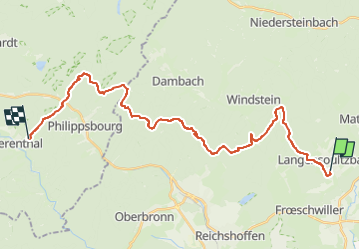

Longueur
28 km

Altitude max
541 m

Dénivelé positif
804 m
Km-Effort
38 km

Altitude min
187 m

Dénivelé négatif
759 m
Boucle
Non
Date de création :
2025-05-12 12:52:05.65
Dernière modification :
2025-05-12 12:52:39.764
5h03
Difficulté : Difficile

Application GPS de randonnée GRATUITE
 SityTrail
IGN / Instituts géographiques
SityTrail Plus
Le monde est à vous
À propos
Randonnée Randonnée équestre de 28 km à découvrir à Grand Est, Bas-Rhin, Langensoultzbach. Cette randonnée est proposée par maureengeorges.
Localisation
Pays :
France
Région :
Grand Est
Département/Province :
Bas-Rhin
Commune :
Langensoultzbach
Localité :
Unknown
Départ:(Dec)
Départ:(UTM)
407514 ; 5424117 (32U) N.
Commentaires