


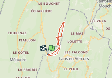
Croix de Jaume GR2

michel38
Utilisateur

Longueur
8,8 km

Altitude max
1635 m

Dénivelé positif
428 m
Km-Effort
14,5 km

Altitude min
1224 m

Dénivelé négatif
423 m
Boucle
Oui
Date de création :
2025-05-26 13:40:37.891
Dernière modification :
2025-05-26 13:41:07.311
3h17
Difficulté : Difficile

Application GPS de randonnée GRATUITE
 SityTrail
IGN / Instituts géographiques
SityTrail Plus
Le monde est à vous
À propos
Randonnée Marche de 8,8 km à découvrir à Auvergne-Rhône-Alpes, Isère, Lans-en-Vercors. Cette randonnée est proposée par michel38.
Localisation
Pays :
France
Région :
Auvergne-Rhône-Alpes
Département/Province :
Isère
Commune :
Lans-en-Vercors
Localité :
Unknown
Départ:(Dec)
Départ:(UTM)
701294 ; 5000625 (31T) N.
Commentaires