


G1 et 2 Stade Neige - Pic St Michel

lionelnottat
Utilisateur
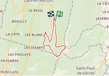

Longueur
12,1 km

Altitude max
1965 m

Dénivelé positif
669 m
Km-Effort
21 km

Altitude min
1343 m

Dénivelé négatif
677 m
Boucle
Oui
Date de création :
2025-06-01 07:13:57.045
Dernière modification :
2025-06-01 07:14:48.616
4h46
Difficulté : Très difficile

Application GPS de randonnée GRATUITE
 SityTrail
IGN / Instituts géographiques
SityTrail Plus
Le monde est à vous
À propos
Randonnée Marche de 12,1 km à découvrir à Auvergne-Rhône-Alpes, Isère, Lans-en-Vercors. Cette randonnée est proposée par lionelnottat.
Localisation
Pays :
France
Région :
Auvergne-Rhône-Alpes
Département/Province :
Isère
Commune :
Lans-en-Vercors
Localité :
Unknown
Départ:(Dec)
Départ:(UTM)
705190 ; 4998631 (31T) N.
Commentaires