Randonnée Marche Mykines - Mykines - Photo
 Geert H.
Geert H.

Utilisateur

© OpenStreetMap contributors
Longueur
Longueur
4,4 km
Altitude max
Altitude max
164 m
Dénivelé positif
Dénivelé positif
241 m
Km-Effort
Km-Effort  
7,6 km
Altitude min
Altitude min
9 m
Dénivelé négatif
Dénivelé négatif
242 m
Boucle
Boucle
Oui
Date de création :
2025-07-05 09:33:13.983
Dernière modification :
2025-07-08 15:09:33.195

(0 Avis)

Marche
Marche
1h33
Difficulté : Facile

Scannez ce code QR pour ouvrir la randonnée dans l'application SityTrail

Application GPS de randonnée GRATUITE

Logo SityTrail SityTrail

IGN / Instituts géographiques

Télécharger SityTrail sur l'App Store Télécharger SityTrail sur Google Play

Logo SityTrail SityTrail Plus

Le monde est à vous

Télécharger SityTrail sur l'App Store Télécharger SityTrail sur Google Play Télécharger SityTrail sur Huawei AppGallery

À propos

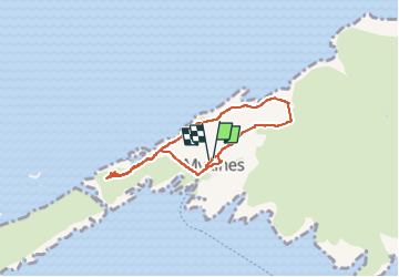
Randonnée Marche de 4,4 km à découvrir à Vága sýsla, Inconnu, Mykines. Cette randonnée est proposée par Geert H..

Description

day tour to Mykines is on many travellers’ bucket lists when visiting the archipelago in the summer months. Most people enjoy the island on a guided day tour with a local tour guide.

Experienced local guides take adventurous travellers along rolling green summer hills and all the way to the remotely located puffins. Travellers spend a day in Mykines to enjoy the astonishing vistas and recharge.

Profil altimétrique

Photos

Localisation

Pays :
Îles Féroé
Région :
Vága sýsla
Département/Province :
Inconnu
Commune :
Mykines
Localité :
Unknown
Départ:(UTM)
570759 ; 6886508 (29V) N.


Fermer
Mes abonnements