Randonnée Marche Saint-Joseph - La Réunion - Boucle du Piton Babet à Saint-Joseph - Photo

La Réunion - Boucle du Piton Babet à Saint-Joseph

 olive2b
olive2b

Utilisateur

© OpenStreetMap contributors
Longueur
Longueur
3,2 km
Altitude max
Altitude max
110 m
Dénivelé positif
Dénivelé positif
113 m
Km-Effort
Km-Effort  
4,7 km
Altitude min
Altitude min
7 m
Dénivelé négatif
Dénivelé négatif
114 m
Boucle
Boucle
Oui
Date de création :
2016-03-09 00:00:00.0
Dernière modification :
2016-03-09 00:00:00.0

(1 Avis)

Marche
Marche
1h01
Difficulté : Très facile

Scannez ce code QR pour ouvrir la randonnée dans l'application SityTrail

Application GPS de randonnée GRATUITE

Logo SityTrail SityTrail

IGN / Instituts géographiques

Télécharger SityTrail sur l'App Store Télécharger SityTrail sur Google Play

Logo SityTrail SityTrail World

Le monde est à vous

Télécharger SityTrail sur l'App Store Télécharger SityTrail sur Google Play Télécharger SityTrail sur Huawei AppGallery

À propos

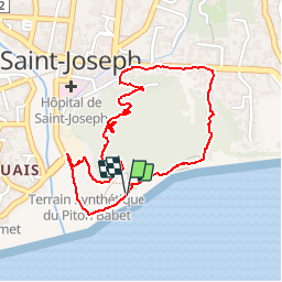
Randonnée Marche de 3,2 km à découvrir à La Réunion, Inconnu, Saint-Joseph. Cette randonnée est proposée par olive2b.

Description

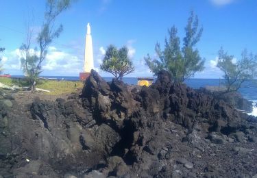
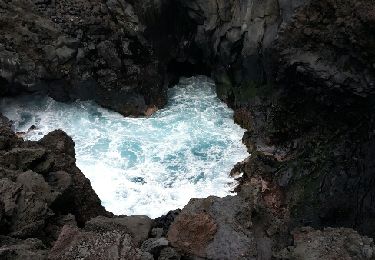
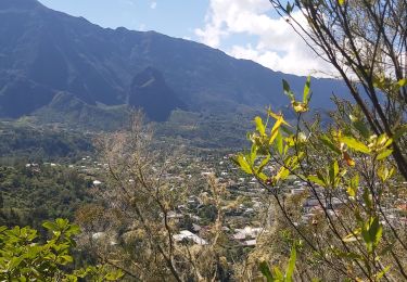
Petite sortie sue Saint-Joseph. La partie par la route pour contourner le piton n'est pas du plus agréable. Petit coin agréable au sommet avec vue sur l'océan.

Profil altimétrique

Photos

28 photos au total. Cliquez sur une photo pour les afficher toutes dans la galerie.

Localisation

Pays :
France
Région :
La Réunion
Département/Province :
Inconnu
Commune :
Saint-Joseph
Localité :
Unknown
Départ:(UTM)
357070 ; 7634741 (40K) S.

Commentaires

Veuillez vous connecter pour laisser un commentaire ou une note


Randonnées à proximité

Randonnée Marche Saint-Joseph - Sentier littoral de Langevin - Photo
Marche
Guy Léandre Jista

Marche

Facile
Saint-Joseph, La Réunion, Inconnu, France
3,4 km | 3,8 km-effort
1h 5min
Oui
Randonnée Marche Saint-Joseph - Langevin 18 03 2015 - Photo
Marche
chouchou-slc

Marche

Facile
Saint-Joseph, La Réunion, Inconnu, France
4,8 km | 5,5 km-effort
3h 2min
Non
Randonnée Marche Saint-Joseph - boucle cascade bras rouge - Photo
Marche
GilbertLP

Marche

Difficile
Saint-Joseph, La Réunion, Inconnu, France
61 km | 121 km-effort
10h 8min
Non
Randonnée V.T.T. Saint-Joseph - st joseph - st Philippe par la route forestière  - Photo
V.T.T.
XavierFaidix

V.T.T.

Moyen
Saint-Joseph, La Réunion, Inconnu, France
42 km | 57 km-effort
4h 30min
Non
Randonnée Marche Saint-Joseph - Le tour des pitons Lambert et Papangues - Photo
Marche
Fdum

Marche

Facile
Saint-Joseph, La Réunion, Inconnu, France
10,3 km | 14,5 km-effort
2h 18min
Oui
Randonnée Marche Saint-Joseph - A/R Terre rouge, Le récif - Photo
Marche
Fdum

Marche

Très facile
Saint-Joseph, La Réunion, Inconnu, France
5 km | 6,8 km-effort
1h 33min
Oui
Randonnée Marche Saint-Joseph - Tour du piton manapany - Photo
Marche
Fdum

Marche

Facile
Saint-Joseph, La Réunion, Inconnu, France
10,1 km | 14,6 km-effort
3h 11min
Oui
Randonnée Marche Saint-Joseph - Piton Entonnoir aller-retour - Photo
Marche
EPSCOORDO

Marche

Moyen
Saint-Joseph, La Réunion, Inconnu, France
9,9 km | 15,7 km-effort
2h 7min
Oui
Randonnée Marche Saint-Joseph - Lycée - Manapany - Photo
Marche
EPSCOORDO

Marche

Moyen
Saint-Joseph, La Réunion, Inconnu, France
5,7 km | 6,8 km-effort
1h 32min
Oui


Fermer
Mes abonnements