


storckensohn

chantalwaltzer
Utilisateur
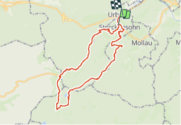

Longueur
17,9 km

Altitude max
1210 m

Dénivelé positif
960 m
Km-Effort
31 km

Altitude min
457 m

Dénivelé négatif
978 m
Boucle
Non
Date de création :
2025-08-14 06:38:48.0
Dernière modification :
2025-08-14 16:25:39.748
9h48
Difficulté : Très difficile

Application GPS de randonnée GRATUITE
 SityTrail
IGN / Instituts géographiques
SityTrail Plus
Le monde est à vous
À propos
Randonnée Marche de 17,9 km à découvrir à Grand Est, Haut-Rhin, Storckensohn. Cette randonnée est proposée par chantalwaltzer.
Description
bien- exigeant
Localisation
Pays :
France
Région :
Grand Est
Département/Province :
Haut-Rhin
Commune :
Storckensohn
Localité :
Unknown
Départ:(Dec)
Départ:(UTM)
347297 ; 5304867 (32T) N.
Commentaires