


Rott kort

flip96
Utilisateur
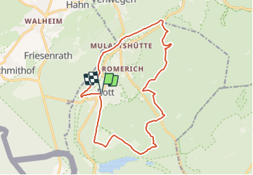

Longueur
16 km

Altitude max
461 m

Dénivelé positif
297 m
Km-Effort
20 km

Altitude min
283 m

Dénivelé négatif
301 m
Boucle
Oui
Date de création :
2015-12-18 00:00:00.0
Dernière modification :
2015-12-18 00:00:00.0
4h17
Difficulté : Moyen

Application GPS de randonnée GRATUITE
 SityTrail
IGN / Instituts géographiques
SityTrail Plus
Le monde est à vous
À propos
Randonnée Marche de 16 km à découvrir à Rhénanie-du-Nord-Westphalie, Région urbaine d'Aix-la-Chapelle, Roetgen. Cette randonnée est proposée par flip96.
Description
Rondwandeling vanuit Rott.
Mooie afwisselende wandeling
Opmerkingen? flip96@home.nl
Localisation
Pays :
Allemagne
Région :
Rhénanie-du-Nord-Westphalie
Département/Province :
Région urbaine d'Aix-la-Chapelle
Commune :
Roetgen
Localité :
Unknown
Départ:(Dec)
Départ:(UTM)
302901 ; 5618212 (32U) N.
Commentaires