


champlon-Lamouline

gk@icedd.be
Utilisateur
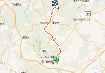

Longueur
27 km

Altitude max
574 m

Dénivelé positif
572 m
Km-Effort
34 km

Altitude min
399 m

Dénivelé négatif
455 m
Boucle
Non
Date de création :
2016-05-22 00:00:00.0
Dernière modification :
2016-05-22 00:00:00.0
1h58
Difficulté : Inconnu

Application GPS de randonnée GRATUITE
 SityTrail
IGN / Instituts géographiques
SityTrail Plus
Le monde est à vous
À propos
Randonnée Vélo de 27 km à découvrir à Wallonie, Luxembourg, Libramont-Chevigny. Cette randonnée est proposée par gk@icedd.be.
Localisation
Pays :
Belgique
Région :
Wallonie
Département/Province :
Luxembourg
Commune :
Libramont-Chevigny
Localité :
Saint-Pierre
Départ:(Dec)
Départ:(UTM)
671259 ; 5529841 (31U) N.
Commentaires