Randonnée Marche Strasbourg - Strasbourg Impérial  - Photo

Strasbourg Impérial

 phil88
phil88

Utilisateur

© OpenStreetMap contributors
Longueur
Longueur
11,6 km
Altitude max
Altitude max
159 m
Dénivelé positif
Dénivelé positif
122 m
Km-Effort
Km-Effort  
13,2 km
Altitude min
Altitude min
134 m
Dénivelé négatif
Dénivelé négatif
116 m
Boucle
Boucle
Oui
Date de création :
2016-06-06 00:00:00.0
Dernière modification :
2016-06-06 00:00:00.0

(0 Avis)

Marche
Marche
3h40
Difficulté : Facile

Scannez ce code QR pour ouvrir la randonnée dans l'application SityTrail

Application GPS de randonnée GRATUITE

Logo SityTrail SityTrail

IGN / Instituts géographiques

Télécharger SityTrail sur l'App Store Télécharger SityTrail sur Google Play

Logo SityTrail SityTrail World

Le monde est à vous

Télécharger SityTrail sur l'App Store Télécharger SityTrail sur Google Play Télécharger SityTrail sur Huawei AppGallery

À propos

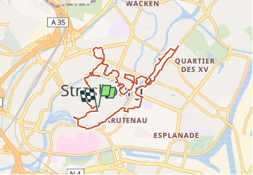
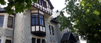
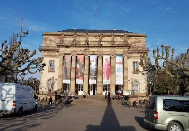
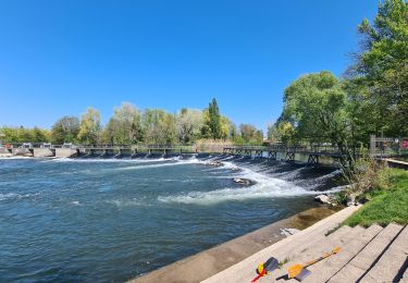
Randonnée Marche de 11,6 km à découvrir à Grand Est, Bas-Rhin, Strasbourg. Cette randonnée est proposée par phil88.

Description

Ballade en ville

Profil altimétrique

Photos

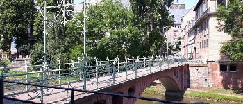
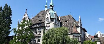
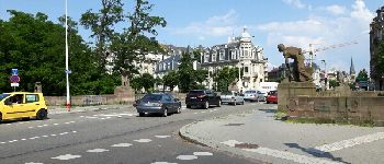
71 photos au total. Cliquez sur une photo pour les afficher toutes dans la galerie.

Points d'intérêt

Point d'intérêt Strasbourg - Banque de France - 1925 - Photo
phil88
Point d'intérêt Strasbourg - Maison de rapport  - 1900 - Photo
phil88
Point d'intérêt Strasbourg - Point 51 - Villa - 1902 - Photo
phil88

Localisation

Pays :
France
Région :
Grand Est
Département/Province :
Bas-Rhin
Commune :
Strasbourg
Localité :
Unknown
Départ:(Dec)
Départ:(UTM)
407807 ; 5381728 (32U) N.

Randonnées à proximité

Randonnée Marche Strasbourg - Strasbourg - Centre historique  - Photo
Marche
phil88

Marche

Facile
(3)
Strasbourg, Grand Est, Bas-Rhin, France
8 km | 9,2 km-effort
2h 11min
Non
Randonnée Marche Strasbourg - Histoires d'eaux.... et de forêts au nord de Strasbourg - Photo
Marche
Claudele

Marche

Difficile
(1)
Strasbourg, Grand Est, Bas-Rhin, France
26 km | 28 km-effort
5h 57min
Oui
Randonnée Marche Strasbourg - Untitled - Photo
Marche
EricMathieu

Marche

Très facile
(1)
Strasbourg, Grand Est, Bas-Rhin, France
6,1 km | 7 km-effort
1h 42min
Oui
Randonnée Marche Bischheim - marchepop bischheim 10km 2021 - Photo
Marche
banitz

Marche

Très facile
(1)
Bischheim, Grand Est, Bas-Rhin, France
10,7 km | 11,8 km-effort
2h 31min
Oui
Randonnée Marche Ostwald - Tayla - Photo
Marche
26051010

Marche

Facile
Ostwald, Grand Est, Bas-Rhin, France
3,9 km | 4,3 km-effort
53min
Non
Randonnée Marche Ostwald - Lundi  - Photo
Marche
26051010

Marche

Très facile
Ostwald, Grand Est, Bas-Rhin, France
8,4 km | 9,2 km-effort
1h 45min
Oui
Randonnée Vélo électrique Ostwald - Promenade Vosges  - Photo
Vélo électrique
26051010

Vélo électrique

Très facile
Ostwald, Grand Est, Bas-Rhin, France
82 km | 94 km-effort
4h 33min
Oui
Randonnée Vélo électrique Ostwald - Nideck carrefour des Pandours  - Photo
Vélo électrique
26051010

Vélo électrique

Moyen
Ostwald, Grand Est, Bas-Rhin, France
86 km | 102 km-effort
5h 10min
Oui
Randonnée V.T.T. Ostwald - Ostwald Etang du loup  - Photo
V.T.T.
26051010

V.T.T.

Moyen
Ostwald, Grand Est, Bas-Rhin, France
78 km | 91 km-effort
4h 27min
Oui


Fermer
Mes abonnements