Randonnée Marche Breitenbach-Haut-Rhin - petit ballon canicule - Photo
 bohynm
bohynm

Utilisateur

© OpenStreetMap contributors
Longueur
Longueur
16,1 km
Altitude max
Altitude max
1266 m
Dénivelé positif
Dénivelé positif
835 m
Km-Effort
Km-Effort  
27 km
Altitude min
Altitude min
433 m
Dénivelé négatif
Dénivelé négatif
833 m
Boucle
Boucle
Oui
Date de création :
2016-08-30 00:00:00.0
Dernière modification :
2016-08-30 00:00:00.0

(0 Avis)

Marche
Marche
4h07
Difficulté : Moyen

Scannez ce code QR pour ouvrir la randonnée dans l'application SityTrail

Application GPS de randonnée GRATUITE

Logo SityTrail SityTrail

IGN / Instituts géographiques

Télécharger SityTrail sur l'App Store Télécharger SityTrail sur Google Play

Logo SityTrail SityTrail World

Le monde est à vous

Télécharger SityTrail sur l'App Store Télécharger SityTrail sur Google Play Télécharger SityTrail sur Huawei AppGallery

À propos

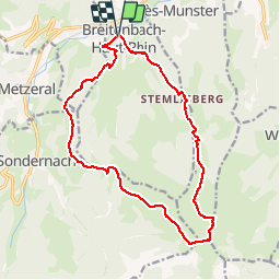
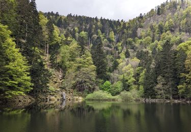
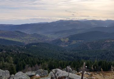
Randonnée Marche de 16,1 km à découvrir à Grand Est, Haut-Rhin, Breitenbach-Haut-Rhin. Cette randonnée est proposée par bohynm.

Profil altimétrique

Photos

Localisation

Pays :
France
Région :
Grand Est
Département/Province :
Haut-Rhin
Commune :
Breitenbach-Haut-Rhin
Localité :
Unknown
Départ:(Dec)
Départ:(UTM)
358340 ; 5320718 (32U) N.

Randonnées à proximité

Randonnée Marche Stosswihr - Tour du belvedere avec le passage sur les crêtes  - Photo
Marche
ocepee

Marche

Très facile
(2)
Stosswihr, Grand Est, Haut-Rhin, France
8,5 km | 0 m-effort
2h 28min
Oui
Randonnée Marche Munster - De Munster aux 3 Fours (Aller) - Munster - Photo
Marche
tracegps

Marche

Difficile
(1)
Munster, Grand Est, Haut-Rhin, France
14,8 km | 27 km-effort
5h 0min
Non
Randonnée Marche Hohrod - Circuit historique 1914-18 Hohrodberg - Linge - Photo
Marche
VacheKiri67

Marche

Moyen
(1)
Hohrod, Grand Est, Haut-Rhin, France
14 km | 19,8 km-effort
5h 50min
Oui
Randonnée Marche Munster - 19.06.13.Munster  - Photo
Marche
ROPPJP

Marche

Très facile
(1)
Munster, Grand Est, Haut-Rhin, France
7,3 km | 10,6 km-effort
2h 10min
Oui
Randonnée V.T.T. Metzeral - Sentier des Névés - Photo
V.T.T.
tracegps

V.T.T.

Très difficile
(1)
Metzeral, Grand Est, Haut-Rhin, France
33 km | 52 km-effort
6h 0min
Oui
Randonnée Marche Mittlach - 2023-09-24 Marche Mittlach 5 Lacs - Photo
Marche
GUIDE
holtzv

Marche

Moyen
Mittlach, Grand Est, Haut-Rhin, France
25 km | 41 km-effort
9h 19min
Oui
Randonnée Marche Sondernach - 2023-05-19 WE Marche Bivouac Massif du Hohneck - Photo
Marche
GUIDE
holtzv

Marche

Moyen
Sondernach, Grand Est, Haut-Rhin, France
46 km | 73 km-effort
16h 41min
Oui
Randonnée Marche Sondernach - 2023-05-19 Marche Schnepfenried vers Lac du Fischboedle - Photo
Marche
GUIDE
holtzv

Marche

Facile
Sondernach, Grand Est, Haut-Rhin, France
9,1 km | 14,1 km-effort
3h 12min
Non
Randonnée Marche Soultzeren - 2022-12-27 Marche Soultzeren Lac Forlet Hautes Huttes Glasborn - Photo
Marche
GUIDE
holtzv

Marche

Très difficile
Soultzeren, Grand Est, Haut-Rhin, France
21 km | 34 km-effort
5h 47min
Oui


Fermer
Mes abonnements