Randonnée Marche Saint-Christophe-en-Oisans - REFUGE DE CHATELLERET depuis LA BERARDE-07-09-2016 - Photo

REFUGE DE CHATELLERET depuis LA BERARDE-07-09-2016

 RD78-38
RD78-38

Utilisateur

© OpenStreetMap contributors
Longueur
Longueur
14,9 km
Altitude max
Altitude max
2306 m
Dénivelé positif
Dénivelé positif
733 m
Km-Effort
Km-Effort  
25 km
Altitude min
Altitude min
1708 m
Dénivelé négatif
Dénivelé négatif
750 m
Boucle
Boucle
Oui
Date de création :
2016-09-12 00:00:00.0
Dernière modification :
2020-07-11 00:22:20.934

(0 Avis)

Marche
Marche
6h30
Difficulté : Facile

Scannez ce code QR pour ouvrir la randonnée dans l'application SityTrail

Application GPS de randonnée GRATUITE

Logo SityTrail SityTrail

IGN / Instituts géographiques

Télécharger SityTrail sur l'App Store Télécharger SityTrail sur Google Play

Logo SityTrail SityTrail World

Le monde est à vous

Télécharger SityTrail sur l'App Store Télécharger SityTrail sur Google Play Télécharger SityTrail sur Huawei AppGallery

À propos

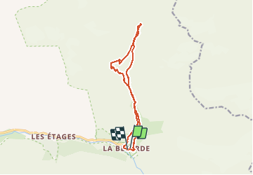
Randonnée Marche de 14,9 km à découvrir à Auvergne-Rhône-Alpes, Isère, Saint-Christophe-en-Oisans. Cette randonnée est proposée par RD78-38.

Description

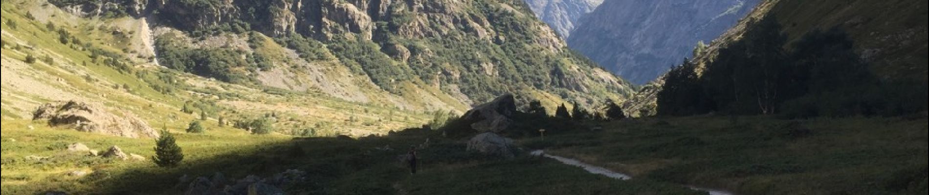
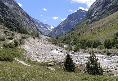
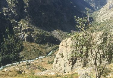
Circuit avec une succession de paysages extraordinaires ( cascades, Pics de LA MEIGE, ruisseaux a l'eau bleue claire, etc.) Aucunes difficulté pour cette randonnée à pentes douces) Nota : Je vous recommande l'Auberge de la MEIJE à LA BERARDE si vous souhaitez passer la nuit sur place avant de faire les Randos du coin en partant de bonheur.

Profil altimétrique

Photos

60 photos au total. Cliquez sur une photo pour les afficher toutes dans la galerie.

Localisation

Pays :
France
Région :
Auvergne-Rhône-Alpes
Département/Province :
Isère
Commune :
Saint-Christophe-en-Oisans
Localité :
Unknown
Départ:(Dec)
Départ:(UTM)
286471 ; 4979060 (32T) N.

Randonnées à proximité

Randonnée Marche Saint-Christophe-en-Oisans - Rando depart du refuge du Carrelet et arrivée à La Berarde - Photo
Marche
HF89

Marche

Facile
Saint-Christophe-en-Oisans, Auvergne-Rhône-Alpes, Isère, France
4,4 km | 5,3 km-effort
1h 10min
Non
Randonnée Marche Saint-Christophe-en-Oisans - Malraux Refuge du Chateleret - Photo
Marche
rapako

Marche

Facile
Saint-Christophe-en-Oisans, Auvergne-Rhône-Alpes, Isère, France
12,1 km | 19,4 km-effort
5h 26min
Oui
Randonnée Marche Saint-Christophe-en-Oisans - Saint-Christophe-en-Oisans - Vallon des Etages - 6.5km 375m 3h20 - 2018 06 19 - Photo
Marche
Orcal37

Marche

Moyen
Saint-Christophe-en-Oisans, Auvergne-Rhône-Alpes, Isère, France
6,3 km | 11,2 km-effort
3h 20min
Oui
Randonnée Marche Saint-Christophe-en-Oisans - Saint-Christophe-en-Oisans - La Bérarde Cotillat (le Châtelleret) - 10.7km 390m 5h30 (45mn) - 2018 06 22 - Photo
Marche
Orcal37

Marche

Moyen
Saint-Christophe-en-Oisans, Auvergne-Rhône-Alpes, Isère, France
10,8 km | 16 km-effort
5h 30min
Oui
Randonnée Marche Saint-Christophe-en-Oisans - MONTÉE vers LE REFUGE DU SOREILLER-08-09-2016 - Photo
Marche
RD78-38

Marche

Moyen
Saint-Christophe-en-Oisans, Auvergne-Rhône-Alpes, Isère, France
5,6 km | 16,9 km-effort
4h 5min
Non
Randonnée Marche Saint-Christophe-en-Oisans - RETOUR du REFUGE DU SOREILLER-09-09-2016 - Photo
Marche
RD78-38

Marche

Moyen
Saint-Christophe-en-Oisans, Auvergne-Rhône-Alpes, Isère, France
5,6 km | 9,6 km-effort
3h 2min
Non
Randonnée Marche Saint-Christophe-en-Oisans - Saint-Christophe-en-Oisans - Vallée du Vénéon les Etages - 5.2km 170m 3h15 - 2015 06 25 - Photo
Marche
Orcal37

Marche

Facile
Saint-Christophe-en-Oisans, Auvergne-Rhône-Alpes, Isère, France
5,2 km | 7,6 km-effort
3h 15min
Oui
Randonnée Marche Saint-Christophe-en-Oisans - Saint-Christophe-en-Oisans - La Bérarde Refuge du Carrelet - 7.9km 220m 2h50 - 2015 06 20 - Photo
Marche
Orcal37

Marche

Moyen
Saint-Christophe-en-Oisans, Auvergne-Rhône-Alpes, Isère, France
7,9 km | 10,8 km-effort
2h 50min
Oui
Randonnée Marche Saint-Christophe-en-Oisans - Saint-Christophe-en-Oisans - La Bérarde la Vallée du Vénéon - 13.4km 390m 4h00 (30mn) - 2014 06 08 - Photo
Marche
Orcal37

Marche

Moyen
Saint-Christophe-en-Oisans, Auvergne-Rhône-Alpes, Isère, France
13,4 km | 18,5 km-effort
4h 1min
Oui


Fermer
Mes abonnements