


Anet 10.59

togolo28
Utilisateur
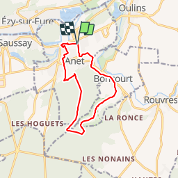

Longueur
10,6 km

Altitude max
139 m

Dénivelé positif
174 m
Km-Effort
12,9 km

Altitude min
65 m

Dénivelé négatif
175 m
Boucle
Oui
Date de création :
2017-12-19 00:00:00.0
Dernière modification :
2019-01-20 15:21:01.708
2h48
Difficulté : Facile

Application GPS de randonnée GRATUITE
 SityTrail
IGN / Instituts géographiques
SityTrail Plus
Le monde est à vous
À propos
Randonnée Marche de 10,6 km à découvrir à Centre-Val de Loire, Eure-et-Loir, Anet. Cette randonnée est proposée par togolo28.
Localisation
Pays :
France
Région :
Centre-Val de Loire
Département/Province :
Eure-et-Loir
Commune :
Anet
Localité :
Unknown
Départ:(Dec)
Départ:(UTM)
385909 ; 5412860 (31U) N.
Commentaires