


Langs de moervaart (7km) StepAway.be

corry.vandenbroeke
Utilisateur
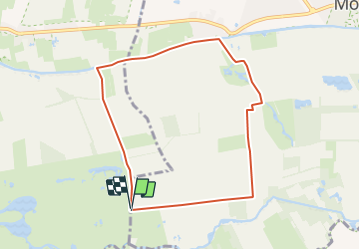

Longueur
7 km

Altitude max
13 m

Dénivelé positif
28 m
Km-Effort
7,4 km

Altitude min
-3 m

Dénivelé négatif
28 m
Boucle
Oui
Date de création :
2016-11-01 00:00:00.0
Dernière modification :
2016-11-01 00:00:00.0
1h12
Difficulté : Très facile

Application GPS de randonnée GRATUITE
 SityTrail
IGN / Instituts géographiques
SityTrail Plus
Le monde est à vous
À propos
Randonnée Marche de 7 km à découvrir à Flandre, Flandre orientale, Moerbeke. Cette randonnée est proposée par corry.vandenbroeke.
Description
OPGEPAST: Nog uit te testen!
Start: Vanaf de parking gelegen aan het provinciaal domein Puyenbroek - Puidonkdreef - Wachtebeke
Localisation
Pays :
Belgique
Région :
Flandre
Département/Province :
Flandre orientale
Commune :
Moerbeke
Localité :
Wachtebeke
Départ:(Dec)
Départ:(UTM)
563161 ; 5667110 (31U) N.
Commentaires