


Linkebeek Proxirando 27 11 2016

ThierryGABRIEL
Utilisateur
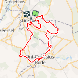

Longueur
18,9 km

Altitude max
138 m

Dénivelé positif
259 m
Km-Effort
22 km

Altitude min
54 m

Dénivelé négatif
259 m
Boucle
Oui
Date de création :
2016-11-27 00:00:00.0
Dernière modification :
2016-11-27 00:00:00.0
5h32
Difficulté : Facile

Application GPS de randonnée GRATUITE
 SityTrail
IGN / Instituts géographiques
SityTrail Plus
Le monde est à vous
À propos
Randonnée Marche de 18,9 km à découvrir à Flandre, Brabant flamand, Linkebeek. Cette randonnée est proposée par ThierryGABRIEL.
Photos


Localisation
Pays :
Belgique
Région :
Flandre
Département/Province :
Brabant flamand
Commune :
Linkebeek
Localité :
Linkebeek
Départ:(Dec)
Départ:(UTM)
594204 ; 5625458 (31U) N.
Commentaires
1ère utilisation avec une balade aux alentours de Linkebeek. J'ai encore beaucoup à apprendre mais je me suis bien débrouillé !application agréable et bien utile.