Randonnée V.T.T. Nailloux - nailloux-20-ils - Photo
 dboudy
dboudy

Utilisateur

© OpenStreetMap contributors
Longueur
Longueur
20 km
Altitude max
Altitude max
287 m
Dénivelé positif
Dénivelé positif
414 m
Km-Effort
Km-Effort  
26 km
Altitude min
Altitude min
197 m
Dénivelé négatif
Dénivelé négatif
419 m
Boucle
Boucle
Non
Date de création :
2014-12-10 00:00:00.0
Dernière modification :
2014-12-10 00:00:00.0

(0 Avis)

V.T.T.
V.T.T.
--
Difficulté : Moyen

Scannez ce code QR pour ouvrir la randonnée dans l'application SityTrail

Application GPS de randonnée GRATUITE

Logo SityTrail SityTrail

IGN / Instituts géographiques

Télécharger SityTrail sur l'App Store Télécharger SityTrail sur Google Play

Logo SityTrail SityTrail World

Le monde est à vous

Télécharger SityTrail sur l'App Store Télécharger SityTrail sur Google Play Télécharger SityTrail sur Huawei AppGallery

À propos

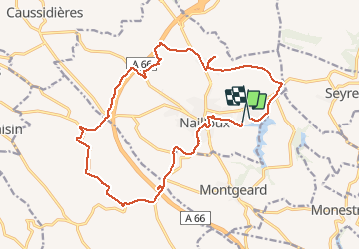
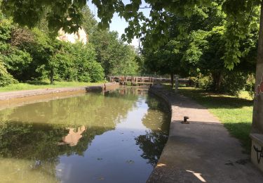
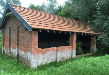
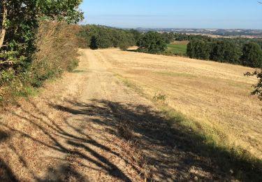
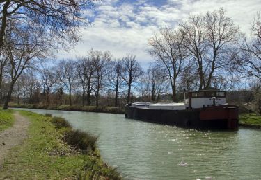
Randonnée V.T.T. de 20 km à découvrir à Occitanie, Haute-Garonne, Nailloux. Cette randonnée est proposée par dboudy.

Profil altimétrique

Photos

Points d'intérêt

Point d'intérêt Nailloux - recoupement - Photo
dboudy
NAILLOUX 
Point d'intérêt Nailloux - saint meen - Photo
dboudy
NAILLOUX 
Point d'intérêt Nailloux - piquetalent - Photo
dboudy
NAILLOUX 
Point d'intérêt Aignes - aignes- d25 - Photo
dboudy
AIGNES 
Point d'intérêt Aignes - le pain parasol  - Photo
dboudy
Point d'intérêt Nailloux - table pic-nic - Photo
dboudy
NAILLOUX 
Point d'intérêt Nailloux - combouil - Photo
dboudy
NAILLOUX 

Localisation

Pays :
France
Région :
Occitanie
Département/Province :
Haute-Garonne
Commune :
Nailloux
Localité :
Unknown
Départ:(Dec)
Départ:(UTM)
389510 ; 4801235 (31T) N.

Randonnées à proximité

Randonnée Marche Montgeard - lac  - Photo
Marche
GUIDE
marmotte65

Marche

Très facile
Montgeard, Occitanie, Haute-Garonne, France
5,4 km | 6,6 km-effort
1h 58min
Oui
Randonnée Marche Gardouch - Canal du Midi - Photo
Marche
richardsimopons

Marche

Difficile
Gardouch, Occitanie, Haute-Garonne, France
10,5 km | 12,7 km-effort
2h 32min
Oui
Randonnée Marche Montgeard - Mongeard et le lac  - Photo
Marche
richardsimopons

Marche

Moyen
Montgeard, Occitanie, Haute-Garonne, France
7,4 km | 9,5 km-effort
1h 50min
Oui
Randonnée Marche Montgeard - Boucle autour de Montréal  - Photo
Marche
Mamilaure

Marche

Moyen
Montgeard, Occitanie, Haute-Garonne, France
56 km | 73 km-effort
2h 44min
Non
Randonnée Marche Montgeard - lac  - Photo
Marche
Mamilaure

Marche

Moyen
Montgeard, Occitanie, Haute-Garonne, France
8 km | 10,3 km-effort
1h 50min
Oui
Randonnée Marche Gardouch - Le canal du Midi - Photo
Marche
richardsimopons

Marche

Difficile
Gardouch, Occitanie, Haute-Garonne, France
11,2 km | 12,1 km-effort
2h 34min
Non
Randonnée Marche Nailloux - Nailloux  - Photo
Marche
richardsimopons

Marche

Moyen
Nailloux, Occitanie, Haute-Garonne, France
7,1 km | 8,8 km-effort
1h 47min
Oui
Randonnée Marche Gardouch - Les Collines du Lauragais  - Photo
Marche
richardsimopons

Marche

Gardouch, Occitanie, Haute-Garonne, France
8,3 km | 10,1 km-effort
2h 21min
Oui
Randonnée Marche Gardouch - Canal du Midi - Ecluse de Laval - En Cassan - Photo
Marche
tracegps

Marche

Facile
Gardouch, Occitanie, Haute-Garonne, France
8,4 km | 8,9 km-effort
1h 40min
Non


Fermer
Mes abonnements