Randonnée Marche Saint-Valery-sur-Somme - saint valerie hourdel - Photo
 epicure
epicure

Utilisateur

© OpenStreetMap contributors
Longueur
Longueur
18,8 km
Altitude max
Altitude max
40 m
Dénivelé positif
Dénivelé positif
98 m
Km-Effort
Km-Effort  
20 km
Altitude min
Altitude min
-1 m
Dénivelé négatif
Dénivelé négatif
101 m
Boucle
Boucle
Non
Date de création :
2016-12-19 00:00:00.0
Dernière modification :
2016-12-19 00:00:00.0

(0 Avis)

Marche
Marche
--
Difficulté : Facile

Scannez ce code QR pour ouvrir la randonnée dans l'application SityTrail

Application GPS de randonnée GRATUITE

Logo SityTrail SityTrail

IGN / Instituts géographiques

Télécharger SityTrail sur l'App Store Télécharger SityTrail sur Google Play

Logo SityTrail SityTrail World

Le monde est à vous

Télécharger SityTrail sur l'App Store Télécharger SityTrail sur Google Play Télécharger SityTrail sur Huawei AppGallery

À propos

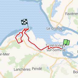
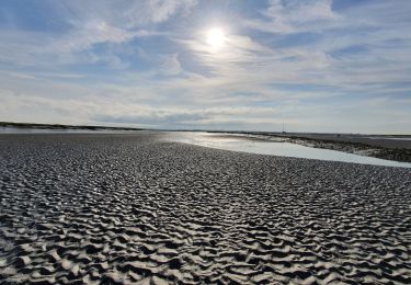
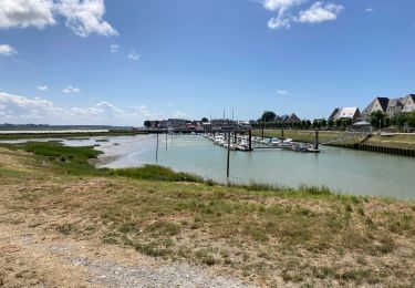
Randonnée Marche de 18,8 km à découvrir à Hauts-de-France, Somme, Saint-Valery-sur-Somme. Cette randonnée est proposée par epicure.

Profil altimétrique

Localisation

Pays :
France
Région :
Hauts-de-France
Département/Province :
Somme
Commune :
Saint-Valery-sur-Somme
Localité :
Unknown
Départ:(Dec)
Départ:(UTM)
403041 ; 5560194 (31U) N.

Randonnées à proximité

Randonnée Marche Saint-Valery-sur-Somme - Balade à Saint-Valéry-sur-Somme - Photo
Marche
GUIDE
Desrumaux

Marche

Facile
(4)
Saint-Valery-sur-Somme, Hauts-de-France, Somme, France
10,4 km | 12,2 km-effort
2h 41min
Oui
Randonnée Marche Estrébœuf - Circuit de Drancourt - Photo
Marche
tracegps

Marche

Moyen
(2)
Estrébœuf, Hauts-de-France, Somme, France
6,6 km | 7,4 km-effort
2h 15min
Oui
Randonnée Marche Saint-Valery-sur-Somme - Balade à Saint-Valery sur Somme - Photo
Marche
tracegps

Marche

Moyen
(3)
Saint-Valery-sur-Somme, Hauts-de-France, Somme, France
7,1 km | 8,6 km-effort
2h 19min
Oui
Randonnée Marche Saint-Valery-sur-Somme - Traversée Baie de Somme - St Valery - Le Crotoy - Photo
Marche
GUIDE
R@ph

Marche

Moyen
Saint-Valery-sur-Somme, Hauts-de-France, Somme, France
8,5 km | 8,8 km-effort
2h 0min
Non
Randonnée Marche Saint-Valery-sur-Somme - w-frankrijk-over-dijken-en-kwelders - Photo
Marche
gpstracks

Marche

Très facile
(2)
Saint-Valery-sur-Somme, Hauts-de-France, Somme, France
13,8 km | 14,9 km-effort
Inconnu
Oui
Randonnée V.T.T. Saint-Valery-sur-Somme - Gravelot Baie de sommes - Photo
V.T.T.
Jeanlouisbray

V.T.T.

Facile
(1)
Saint-Valery-sur-Somme, Hauts-de-France, Somme, France
44 km | 47 km-effort
4h 56min
Oui
Randonnée Vélo Le Crotoy - Crotoy - Marquenterre - Photo
Vélo
jacques.moulin@hotmail.com

Vélo

Moyen
(1)
Le Crotoy, Hauts-de-France, Somme, France
18,3 km | 19,2 km-effort
1h 8min
Oui
Randonnée Marche Le Crotoy - traversée baie somme et train - Photo
Marche
lefrancm

Marche

Très facile
(1)
Le Crotoy, Hauts-de-France, Somme, France
24 km | 25 km-effort
6h 58min
Non
Randonnée Marche Le Crotoy - Port du crotoy - port de St Valéry sur somme par GR - Photo
Marche
ash

Marche

Très facile
(1)
Le Crotoy, Hauts-de-France, Somme, France
12,3 km | 12,7 km-effort
2h 40min
Non


Fermer
Mes abonnements