Randonnée Marche Sainte-Eulalie-de-Cernon - Sainte Eulalie - bloucle nord. - Photo

Sainte Eulalie - bloucle nord.

 octavio
octavio

Utilisateur

© OpenStreetMap contributors
Longueur
Longueur
8,7 km
Altitude max
Altitude max
827 m
Dénivelé positif
Dénivelé positif
308 m
Km-Effort
Km-Effort  
12,8 km
Altitude min
Altitude min
576 m
Dénivelé négatif
Dénivelé négatif
305 m
Boucle
Boucle
Oui
Date de création :
2014-12-10 00:00:00.0
Dernière modification :
2014-12-10 00:00:00.0

(1 Avis)

Marche
Marche
--
Difficulté : Facile

Scannez ce code QR pour ouvrir la randonnée dans l'application SityTrail

Application GPS de randonnée GRATUITE

Logo SityTrail SityTrail

IGN / Instituts géographiques

Télécharger SityTrail sur l'App Store Télécharger SityTrail sur Google Play

Logo SityTrail SityTrail World

Le monde est à vous

Télécharger SityTrail sur l'App Store Télécharger SityTrail sur Google Play Télécharger SityTrail sur Huawei AppGallery

À propos

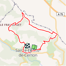
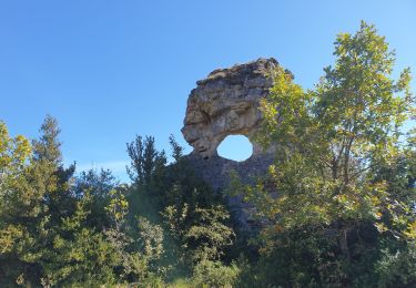
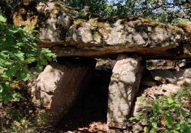
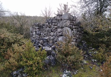
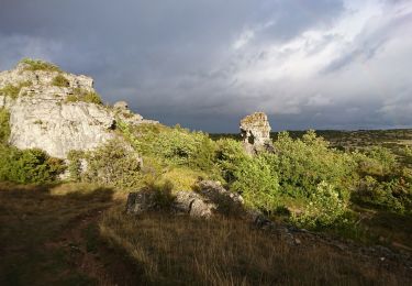
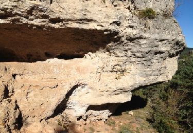
Randonnée Marche de 8,7 km à découvrir à Occitanie, Aveyron, Sainte-Eulalie-de-Cernon. Cette randonnée est proposée par octavio.

Description

Boucle nord de Sainte Eulalie de Cernon.
Très belle vue sur la vallée du Cernon, chemin très agréable sur le causse.

Profil altimétrique

Localisation

Pays :
France
Région :
Occitanie
Département/Province :
Aveyron
Commune :
Sainte-Eulalie-de-Cernon
Localité :
Unknown
Départ:(Dec)
Départ:(UTM)
511005 ; 4869882 (31T) N.

Commentaires

Veuillez vous connecter pour laisser un commentaire ou une note


Randonnées à proximité

Randonnée Marche Sainte-Eulalie-de-Cernon - Sainte Eulalie de Cernon - Photo
Marche
Bobol

Marche

Moyen
(1)
Sainte-Eulalie-de-Cernon, Occitanie, Aveyron, France
11,8 km | 16,9 km-effort
4h 15min
Oui
Randonnée Marche La Cavalerie - num.la cavalerie le viala - Photo
Marche
nanie

Marche

Moyen
La Cavalerie, Occitanie, Aveyron, France
15,2 km | 20 km-effort
3h 50min
Non
Randonnée Marche Sainte-Eulalie-de-Cernon - ste eulalie in live - Photo
Marche
CASSISFRAMBOISE

Marche

Moyen
Sainte-Eulalie-de-Cernon, Occitanie, Aveyron, France
16,8 km | 25 km-effort
4h 8min
Oui
Randonnée Marche Sainte-Eulalie-de-Cernon - ste eulalie - Photo
Marche
CASSISFRAMBOISE

Marche

Facile
Sainte-Eulalie-de-Cernon, Occitanie, Aveyron, France
8,8 km | 12,6 km-effort
2h 24min
Oui
Randonnée Marche Lapanouse-de-Cernon - lapanouse in live - Photo
Marche
CASSISFRAMBOISE

Marche

Moyen
Lapanouse-de-Cernon, Occitanie, Aveyron, France
12,3 km | 19,3 km-effort
3h 23min
Oui
Randonnée Marche La Cavalerie - St Eulalie de Cernon - Photo
Marche
nolsim

Marche

Moyen
La Cavalerie, Occitanie, Aveyron, France
13,5 km | 19,1 km-effort
3h 9min
Non
Randonnée Marche Sainte-Eulalie-de-Cernon - boîtes jaunes - Photo
Marche
at12

Marche

Très facile
Sainte-Eulalie-de-Cernon, Occitanie, Aveyron, France
14,5 km | 17,8 km-effort
3h 38min
Oui
Randonnée Marche Viala-du-Pas-de-Jaux - lapanouse - Photo
Marche
Nepalais

Marche

Très facile
Viala-du-Pas-de-Jaux, Occitanie, Aveyron, France
4,2 km | 4,9 km-effort
1h 50min
Non
Randonnée Marche Sainte-Eulalie-de-Cernon - autour de Sté eu l'amie - Photo
Marche
colber

Marche

Très facile
Sainte-Eulalie-de-Cernon, Occitanie, Aveyron, France
10 km | 13,9 km-effort
2h 49min
Oui


Fermer
Mes abonnements