


Club VTT IMEGB Metabief 3 2011-07-07 16h42m13

norbertmarteau
Utilisateur
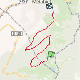

Longueur
6,2 km

Altitude max
1413 m

Dénivelé positif
23 m
Km-Effort
7,8 km

Altitude min
1008 m

Dénivelé négatif
427 m
Boucle
Non
Date de création :
2014-12-10 00:00:00.0
Dernière modification :
2014-12-10 00:00:00.0
--
Difficulté : Facile

Application GPS de randonnée GRATUITE
 SityTrail
IGN / Instituts géographiques
SityTrail Plus
Le monde est à vous
À propos
Randonnée V.T.T. de 6,2 km à découvrir à Bourgogne-Franche-Comté, Doubs, Métabief. Cette randonnée est proposée par norbertmarteau.
Localisation
Pays :
France
Région :
Bourgogne-Franche-Comté
Département/Province :
Doubs
Commune :
Métabief
Localité :
Unknown
Départ:(Dec)
Départ:(UTM)
297871 ; 5180879 (32T) N.
Commentaires