


Fondamente variante

grageot
Utilisateur
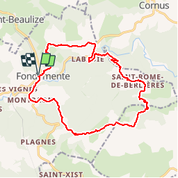

Longueur
18,6 km

Altitude max
834 m

Dénivelé positif
677 m
Km-Effort
28 km

Altitude min
470 m

Dénivelé négatif
678 m
Boucle
Oui
Date de création :
2017-03-22 00:00:00.0
Dernière modification :
2017-03-22 00:00:00.0
5h28
Difficulté : Moyen

Application GPS de randonnée GRATUITE
 SityTrail
IGN / Instituts géographiques
SityTrail Plus
Le monde est à vous
À propos
Randonnée Marche de 18,6 km à découvrir à Occitanie, Aveyron, Fondamente. Cette randonnée est proposée par grageot.
Description
Fondamente variante du topo de Coulombf qui évite le retour par la route
Localisation
Pays :
France
Région :
Occitanie
Département/Province :
Aveyron
Commune :
Fondamente
Localité :
Unknown
Départ:(Dec)
Départ:(UTM)
509769 ; 4858163 (31T) N.
Commentaires