Randonnée Marche Berrias-et-Casteljau - 07 Aven de l'Assiette Païolive 23-04-17 - Photo

07 Aven de l'Assiette Païolive 23-04-17

 silvestreclaudine
silvestreclaudine

Utilisateur

© OpenStreetMap contributors
Longueur
Longueur
13,8 km
Altitude max
Altitude max
250 m
Dénivelé positif
Dénivelé positif
234 m
Km-Effort
Km-Effort  
16,9 km
Altitude min
Altitude min
129 m
Dénivelé négatif
Dénivelé négatif
234 m
Boucle
Boucle
Oui
Date de création :
2017-04-23 00:00:00.0
Dernière modification :
2019-09-07 17:16:42.585

(0 Avis)

Marche
Marche
5h50
Difficulté : Très facile

Scannez ce code QR pour ouvrir la randonnée dans l'application SityTrail

Application GPS de randonnée GRATUITE

Logo SityTrail SityTrail

IGN / Instituts géographiques

Télécharger SityTrail sur l'App Store Télécharger SityTrail sur Google Play

Logo SityTrail SityTrail World

Le monde est à vous

Télécharger SityTrail sur l'App Store Télécharger SityTrail sur Google Play Télécharger SityTrail sur Huawei AppGallery

À propos

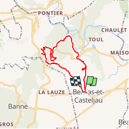
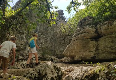
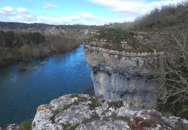
Randonnée Marche de 13,8 km à découvrir à Auvergne-Rhône-Alpes, Ardèche, Berrias-et-Casteljau. Cette randonnée est proposée par silvestreclaudine.
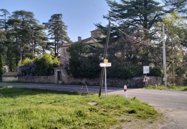
Description

Depart de Berrias

Profil altimétrique

Photos

Localisation

Pays :
France
Région :
Auvergne-Rhône-Alpes
Département/Province :
Ardèche
Commune :
Berrias-et-Casteljau
Localité :
Unknown
Départ:(Dec)
Départ:(UTM)
595592 ; 4914210 (31T) N.

Randonnées à proximité

Randonnée Marche Saint-Paul-le-Jeune - Du Viaduc de Doulovy au Fort de Banne - Saint Paul le Jeune - Photo
Marche
tracegps

Marche

Difficile
(2)
Saint-Paul-le-Jeune, Auvergne-Rhône-Alpes, Ardèche, France
16,1 km | 24 km-effort
5h 0min
Oui
Randonnée Marche Banne - Autour de Banne  - Photo
Marche
GUIDE
nadinebondoux

Marche

Difficile
Banne, Auvergne-Rhône-Alpes, Ardèche, France
19,8 km | 28 km-effort
5h 46min
Oui
Randonnée V.T.T. Les Vans - Vans banne Berrias retour - Photo
V.T.T.
WALCH

V.T.T.

Moyen
(1)
Les Vans, Auvergne-Rhône-Alpes, Ardèche, France
23 km | 28 km-effort
2h 10min
Non
Randonnée Marche Berrias-et-Casteljau - Wikiloc Bois de Paiolive (PVDB) - Photo
Marche
GUIDE
Peter.vdbergh

Marche

Moyen
Berrias-et-Casteljau, Auvergne-Rhône-Alpes, Ardèche, France
9,9 km | 12,3 km-effort
4h 24min
Oui
Randonnée Marche Les Vans - Bois de Païolive - Photo
Marche
Bobol

Marche

Moyen
(1)
Les Vans, Auvergne-Rhône-Alpes, Ardèche, France
2,9 km | 3,3 km-effort
1h 33min
Oui
Randonnée Marche Berrias-et-Casteljau - paiolive - Photo
Marche
gvanpouille

Marche

Très facile
(1)
Berrias-et-Casteljau, Auvergne-Rhône-Alpes, Ardèche, France
5,6 km | 6,7 km-effort
2h 16min
Oui
Randonnée V.T.T. Berrias-et-Casteljau - Berias et environ - Photo
V.T.T.
gvanpouille

V.T.T.

Difficile
(1)
Berrias-et-Casteljau, Auvergne-Rhône-Alpes, Ardèche, France
23 km | 27 km-effort
1h 41min
Oui
Randonnée Marche Banne - 07_Banne_8km290m - Photo
Marche
SyMA

Marche

Facile
Banne, Auvergne-Rhône-Alpes, Ardèche, France
8 km | 11,9 km-effort
2h 36min
Oui
Randonnée Marche Chandolas - Maisoneuve-Ron-Redon-Chandolas.8km+101m - Photo
Marche
ganinette

Marche

Moyen
Chandolas, Auvergne-Rhône-Alpes, Ardèche, France
8 km | 9,4 km-effort
2h 7min
Oui


Fermer
Mes abonnements