Randonnée Marche Nogaro - OR-6947751--Nogaro:Nogaro-Lelin-Lapujolle-arblade le bas-7 - Photo

OR-6947751--Nogaro:Nogaro-Lelin-Lapujolle-arblade le bas-7

 Compostel61
Compostel61

Utilisateur

© OpenStreetMap contributors
Longueur
Longueur
21 km
Altitude max
Altitude max
165 m
Dénivelé positif
Dénivelé positif
342 m
Km-Effort
Km-Effort  
25 km
Altitude min
Altitude min
92 m
Dénivelé négatif
Dénivelé négatif
290 m
Boucle
Boucle
Non
Date de création :
2017-06-21 00:00:00.0
Dernière modification :
2017-06-21 00:00:00.0

(1 Avis)

Marche
Marche
5h25
Difficulté : Inconnu

Scannez ce code QR pour ouvrir la randonnée dans l'application SityTrail

Application GPS de randonnée GRATUITE

Logo SityTrail SityTrail

IGN / Instituts géographiques

Télécharger SityTrail sur l'App Store Télécharger SityTrail sur Google Play

Logo SityTrail SityTrail World

Le monde est à vous

Télécharger SityTrail sur l'App Store Télécharger SityTrail sur Google Play Télécharger SityTrail sur Huawei AppGallery

À propos

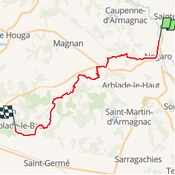
Randonnée Marche de 21 km à découvrir à Occitanie, Gers, Nogaro. Cette randonnée est proposée par Compostel61.

Description

étape de Compostelle

Profil altimétrique

Localisation

Pays :
France
Région :
Occitanie
Département/Province :
Gers
Commune :
Nogaro
Localité :
Unknown
Départ:(Dec)
Départ:(UTM)
738934 ; 4850726 (30T) N.

Commentaires

Veuillez vous connecter pour laisser un commentaire ou une note


rando arj


Randonnées à proximité

Randonnée Marche Cravencères - mon Compostelle douzième étape - Photo
Marche
Ardeiserois

Marche

Moyen
Cravencères, Occitanie, Gers, France
35 km | 40 km-effort
7h 28min
Non
Randonnée Marche Nogaro - GR 65 Nogaro > Aire sur Adour - Photo
Marche
choubaka77

Marche

Difficile
Nogaro, Occitanie, Gers, France
26 km | 30 km-effort
6h 57min
Non
Randonnée Marche Nogaro - 3 Nogaro - Photo
Marche
GUIDE
thonyc

Marche

Difficile
Nogaro, Occitanie, Gers, France
28 km | 33 km-effort
8h 1min
Non
Randonnée Marche Nogaro - Camino 1 étape 25 du 20.08.2023 - Photo
Marche
bene_dictus77

Marche

Moyen
Nogaro, Occitanie, Gers, France
29 km | 34 km-effort
7h 44min
Non
Randonnée Marche Cravencères - ferme du Hage-Lanne Soubiran  - Photo
Marche
cutter

Marche

Facile
Cravencères, Occitanie, Gers, France
15 km | 18,3 km-effort
6h 8min
Non
Randonnée Marche Nogaro - StJ-J38-Nogaro-Aire sur l'Adour - Photo
Marche
Bonsaicd

Marche

Très difficile
Nogaro, Occitanie, Gers, France
28 km | 32 km-effort
6h 52min
Non
Randonnée Marche Nogaro - Compostelle 26 - Nogaro -> Aire-sur-l'Adour - Photo
Marche
uru2010

Marche

Moyen
Nogaro, Occitanie, Gers, France
29 km | 33 km-effort
7h 5min
Non
Randonnée Marche Caupenne-d'Armagnac - Caupenne d'armagnac  - Photo
Marche
DuMarsan

Marche

Facile
Caupenne-d'Armagnac, Occitanie, Gers, France
12 km | 13,8 km-effort
2h 25min
Oui
Randonnée Marche Nogaro - Nogaro-Aire sur l'Adour - Photo
Marche
chouk1

Marche

Difficile
Nogaro, Occitanie, Gers, France
29 km | 34 km-effort
7h 25min
Non


Fermer
Mes abonnements