Randonnée Marche Raon-sur-Plaine - Cascade de la Crache - Photo
 Le_Grand
Le_Grand

Utilisateur

© OpenStreetMap contributors
Longueur
Longueur
3,8 km
Altitude max
Altitude max
620 m
Dénivelé positif
Dénivelé positif
157 m
Km-Effort
Km-Effort  
5,9 km
Altitude min
Altitude min
463 m
Dénivelé négatif
Dénivelé négatif
157 m
Boucle
Boucle
Oui
Date de création :
2018-09-03 11:42:51.393
Dernière modification :
2018-09-03 11:42:51.402

(1 Avis)

Marche
Marche
1h16
Difficulté : Facile

Scannez ce code QR pour ouvrir la randonnée dans l'application SityTrail

Application GPS de randonnée GRATUITE

Logo SityTrail SityTrail

IGN / Instituts géographiques

Télécharger SityTrail sur l'App Store Télécharger SityTrail sur Google Play

Logo SityTrail SityTrail World

Le monde est à vous

Télécharger SityTrail sur l'App Store Télécharger SityTrail sur Google Play Télécharger SityTrail sur Huawei AppGallery

À propos

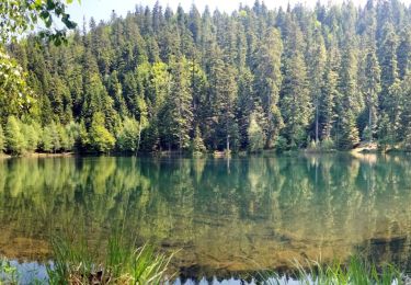
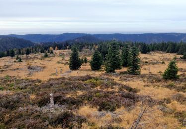
Randonnée Marche de 3,8 km à découvrir à Grand Est, Vosges, Raon-sur-Plaine. Cette randonnée est proposée par Le_Grand.

Description

Circuit très agréable au pied du Donon sous les frondaisons avec pour point d'intérêt la cascade de la Crache. On peut revenir sur ses pas si on ne veut pas faire le circuit complet.

Profil altimétrique

Localisation

Pays :
France
Région :
Grand Est
Département/Province :
Vosges
Commune :
Raon-sur-Plaine
Localité :
Unknown
Départ:(Dec)
Départ:(UTM)
359591 ; 5374132 (32U) N.

Commentaires

Veuillez vous connecter pour laisser un commentaire ou une note


On n'a pas réussi à suivre le parcours indiqué


Randonnées à proximité

Randonnée Marche Grandfontaine - Donon sentier des casemates - sud - Photo
Marche
VacheKiri67

Marche

Moyen
(1)
Grandfontaine, Grand Est, Bas-Rhin, France
12,6 km | 16,9 km-effort
4h 13min
Oui
Randonnée Marche Grandfontaine - Le site des 2 Donons - Photo
Marche
VacheKiri67

Marche

Moyen
(4)
Grandfontaine, Grand Est, Bas-Rhin, France
12,6 km | 19,4 km-effort
4h 52min
Oui
Randonnée Marche Moussey - Col de Prayé - Photo
Marche
VacheKiri67

Marche

Difficile
(1)
Moussey, Grand Est, Vosges, France
16,8 km | 23 km-effort
6h 55min
Oui
Randonnée Marche Grandfontaine - 2023-05-29 Marche Les Minières Lac de la Maix - Photo
Marche
GUIDE
holtzv

Marche

Moyen
Grandfontaine, Grand Est, Bas-Rhin, France
22 km | 34 km-effort
7h 43min
Oui
Randonnée Marche Grandfontaine - 2022-11-12 Marche Grandfontaine Tête Mathis Col de Praye La Corbeille - Photo
Marche
GUIDE
holtzv

Marche

Moyen
Grandfontaine, Grand Est, Bas-Rhin, France
15,3 km | 23 km-effort
4h 34min
Oui
Randonnée A pied Grandfontaine - Circuit du Chemin d'Allemagne - Photo
A pied
PRO

A pied

Facile
Grandfontaine, Grand Est, Bas-Rhin, France
8,7 km | 13,9 km-effort
3h 10min
Non
Randonnée Marche Grandfontaine - 2020-09-20 Marche Donon Petit Donon Casemates - Photo
Marche
GUIDE
holtzv

Marche

Très facile
(1)
Grandfontaine, Grand Est, Bas-Rhin, France
13,4 km | 20 km-effort
4h 17min
Oui
Randonnée Marche Grandfontaine - 2019-01-05 Marche Temple du Donon - Photo
Marche
GUIDE
holtzv

Marche

Moyen
Grandfontaine, Grand Est, Bas-Rhin, France
5,6 km | 9,3 km-effort
1h 54min
Oui
Randonnée Marche Grandfontaine - 2024-01-13 Rando Polaire Abri Roule Bacon vers Col Engin - Photo
Marche
GUIDE
holtzv

Marche

Difficile
Grandfontaine, Grand Est, Bas-Rhin, France
24 km | 34 km-effort
7h 41min
Non


Fermer
Mes abonnements