![](/images/other/stat-length.png)
![Randonnée Vélo Mettet - Art et culture - Photo](https://media.geolcdn.com/t/1900/400/ext.pjpeg?maxdim=2&url=https%3A%2F%2Fstatic1.geolcdn.com%2Fsiteimages%2Fupload%2Ffiles%2F1524743154velo.jpg)
Art et culture
Maison du Tourisme Explore Meuse
Vivez Explore Meuse GUIDE+
![Longueur](/images/other/stat-length.png)
Longueur
18,8 km
![Altitude max](https://static1.geolcdn.com/siteimages/upload/files/1508320355ic_sort_altitude_max_24dp.png)
Altitude max
273 m
![Dénivelé positif](https://static1.geolcdn.com/siteimages/upload/files/1508320355ic_sort_den_pos_24dp.png)
Dénivelé positif
244 m
![Km-Effort](/images/other/stat-length.png)
Km-Effort
22 km
![Altitude min](https://static1.geolcdn.com/siteimages/upload/files/1508320355ic_sort_altitude_min_24dp.png)
Altitude min
219 m
![Dénivelé négatif](https://static1.geolcdn.com/siteimages/upload/files/1508320355ic_sort_den_neg_24dp.png)
Dénivelé négatif
242 m
![Boucle](https://static1.geolcdn.com/siteimages/upload/files/16400158638029165_repeat_loop_refresh_sync_direction_icon.png)
Boucle
Oui
Date de création :
2017-05-30 00:00:00.0
Dernière modification :
2017-05-30 00:00:00.0
![Vélo](https://static1.geolcdn.com/sitytour/trail-icons/200.png)
1h17
Difficulté : Inconnu
![Scannez ce code QR pour ouvrir la randonnée dans l'application SityTrail](https://capi.geolives.com/qq0zvz2zws4bq2lad0pu/sitytour/trails/763036/qr.png?size=200)
Application GPS de randonnée GRATUITE
À propos
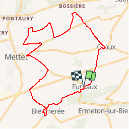
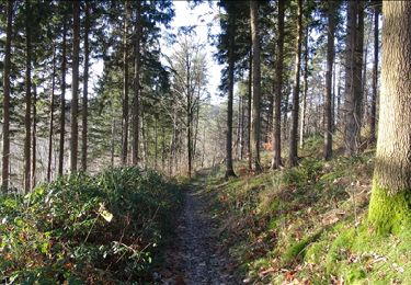
Randonnée Vélo de 18,8 km à découvrir à Wallonie, Namur, Mettet. Cette randonnée est proposée par Maison du Tourisme Explore Meuse.
Description
Ce circuit champêtre nous entraîne à la découverte du patrimoine et de l'environnement de quatre villages pittoresques de la Commune de Mettet: Furnaux, Biesmerée, Bossière et Graux.
Points d'intérêt
Localisation
Pays :
Belgique
Région :
Wallonie
Département/Province :
Namur
Commune :
Mettet
Localité :
Furnaux
Départ:(Dec)
Départ:(UTM)
621398 ; 5574254 (31U) N.
Commentaires
Randonnées à proximité
![Randonnée Marche Mettet - RB-Na-23_Biesmerée - Photo](https://media.geolcdn.com/t/375/260/ext.jpg?maxdim=2&url=https%3A%2F%2Fmedia.geolcdn.com%2Ff%2F5fbb8ead-50d3-47aa-b00f-4ac497510b7f.JPG)
![Marche Marche](https://static1.geolcdn.com/sitytour/trail-icons/101.png)
RB-Na-23_Biesmerée
Marche
Très difficile
(8)
Mettet,
Wallonie,
Namur,
Belgique
![](/images/other/stat-length.png)
24 km | 29 km-effort
6h 39min
![](https://static1.geolcdn.com/siteimages/upload/files/16400158638029165_repeat_loop_refresh_sync_direction_icon.png)
Oui
![Randonnée Marche Anhée - RB-Na-16_Maredsous - Photo](https://media.geolcdn.com/t/375/260/ext.jpg?maxdim=2&url=https%3A%2F%2Fservices.sitytrail.com%2FGeolivesWS%2FDownloadMedia.ashx%3FTrailID%3D252846%26Media%3D757ed732-5926-4a49-9c27-a2a6c3abf11c.jpg)
![Marche Marche](https://static1.geolcdn.com/sitytour/trail-icons/101.png)
RB-Na-16_Maredsous
Marche
Moyen
(19)
Anhée,
Wallonie,
Namur,
Belgique
![](/images/other/stat-length.png)
18,3 km | 24 km-effort
5h 13min
![](https://static1.geolcdn.com/siteimages/upload/files/16400158638029165_repeat_loop_refresh_sync_direction_icon.png)
Oui
![Randonnée Marche Mettet - RB-Na-23_Biesmerée-via-racc - Photo](https://media.geolcdn.com/t/375/260/ext.jpg?maxdim=2&url=https%3A%2F%2Fmedia.geolcdn.com%2Ff%2F4a23ab11-4064-4481-945b-ca937cc46bf3.JPG)
![Marche Marche](https://static1.geolcdn.com/sitytour/trail-icons/101.png)
RB-Na-23_Biesmerée-via-racc
Marche
Difficile
(8)
Mettet,
Wallonie,
Namur,
Belgique
![](/images/other/stat-length.png)
14 km | 16,7 km-effort
3h 47min
![](https://static1.geolcdn.com/siteimages/upload/files/16400158638029165_repeat_loop_refresh_sync_direction_icon.png)
Oui
![Randonnée Marche Anhée - RB-Na-16_Maredsous_via-racc - Photo](https://media.geolcdn.com/t/375/260/ext.jpg?maxdim=2&url=https%3A%2F%2Fstatic1.geolcdn.com%2Fsiteimages%2Fupload%2Ffiles%2F1553511878bg_sport_marche.png)
![Marche Marche](https://static1.geolcdn.com/sitytour/trail-icons/101.png)
RB-Na-16_Maredsous_via-racc
Marche
Facile
(15)
Anhée,
Wallonie,
Namur,
Belgique
![](/images/other/stat-length.png)
13 km | 16,6 km-effort
3h 40min
![](https://static1.geolcdn.com/siteimages/upload/files/16400158638029165_repeat_loop_refresh_sync_direction_icon.png)
Oui
![Randonnée Marche Anhée - Balade de l'abbaye de Maredsous à Ermeton-sur-Biert - Photo](https://media.geolcdn.com/t/375/260/ext.jpg?maxdim=2&url=https%3A%2F%2Fservices.sitytrail.com%2FGeolivesWS%2FDownloadMedia.ashx%3FTrailID%3D1068875%26Media%3D20181106140411.jpg)
![Marche Marche](https://static1.geolcdn.com/sitytour/trail-icons/101.png)
Balade de l'abbaye de Maredsous à Ermeton-sur-Biert
Marche
Facile
(4)
Anhée,
Wallonie,
Namur,
Belgique
![](/images/other/stat-length.png)
9,2 km | 11,9 km-effort
2h 32min
![](https://static1.geolcdn.com/siteimages/upload/files/16400158638029165_repeat_loop_refresh_sync_direction_icon.png)
Oui
![Randonnée Marche Anhée - Balade à Denée - Photo](https://media.geolcdn.com/t/375/260/ext.jpg?maxdim=2&url=https%3A%2F%2Fservices.sitytrail.com%2FGeolivesWS%2FDownloadMedia.ashx%3FTrailID%3D274406%26Media%3Dfced633a-60e9-42df-93a1-c2f30963bb68.JPG)
![Marche Marche](https://static1.geolcdn.com/sitytour/trail-icons/101.png)
Balade à Denée
Marche
Très facile
(1)
Anhée,
Wallonie,
Namur,
Belgique
![](/images/other/stat-length.png)
5,8 km | 7,4 km-effort
1h 35min
![](https://static1.geolcdn.com/siteimages/upload/files/16400158638029165_repeat_loop_refresh_sync_direction_icon.png)
Oui
![Randonnée Marche Anhée - MAREDSOUS ... par l'Abbaye de Maredret et la campagne de Bonsin. - Photo](https://media.geolcdn.com/t/375/260/ext.jpg?maxdim=2&url=https%3A%2F%2Fservices.sitytrail.com%2FGeolivesWS%2FDownloadMedia.ashx%3FTrailID%3D1072991%26Media%3D)
![Marche Marche](https://static1.geolcdn.com/sitytour/trail-icons/101.png)
MAREDSOUS ... par l'Abbaye de Maredret et la campagne de Bonsin.
Marche
Facile
(1)
Anhée,
Wallonie,
Namur,
Belgique
![](/images/other/stat-length.png)
9,3 km | 12,3 km-effort
2h 0min
![](https://static1.geolcdn.com/siteimages/upload/files/16400158638029165_repeat_loop_refresh_sync_direction_icon.png)
Oui
![Randonnée Marche Anhée - Maredsous 18/07/20 - Photo](https://media.geolcdn.com/t/375/260/ext.jpg?maxdim=2&url=https%3A%2F%2Fmedia.geolcdn.com%2Ff%2Fafcc3f4a-54e6-4bc8-bf4e-8a6ff17b3795.jpg)
![Marche Marche](https://static1.geolcdn.com/sitytour/trail-icons/101.png)
Maredsous 18/07/20
Marche
Difficile
(1)
Anhée,
Wallonie,
Namur,
Belgique
![](/images/other/stat-length.png)
7,6 km | 10 km-effort
1h 43min
![](https://static1.geolcdn.com/siteimages/upload/files/16400158638029165_repeat_loop_refresh_sync_direction_icon.png)
Oui
![Randonnée Marche Mettet - De Furnaux à Ermeton-sur-Biert - Photo](https://media.geolcdn.com/t/375/260/ext.jpg?maxdim=2&url=https%3A%2F%2Fservices.sitytrail.com%2FGeolivesWS%2FDownloadMedia.ashx%3FTrailID%3D166393%26Media%3Dd65d6cdc-c068-4197-b7e1-f052e1a7e6bf.JPG)
![Marche Marche](https://static1.geolcdn.com/sitytour/trail-icons/101.png)
De Furnaux à Ermeton-sur-Biert
Marche
Très facile
(3)
Mettet,
Wallonie,
Namur,
Belgique
![](/images/other/stat-length.png)
7,4 km | 9,5 km-effort
2h 4min
![](https://static1.geolcdn.com/siteimages/upload/files/16400158638029165_repeat_loop_refresh_sync_direction_icon.png)
Oui
très chouette balade