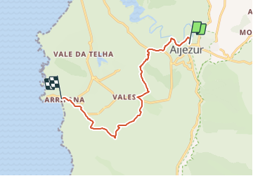
38 km | 46 km-effort
A - Aljesur - Arrifana - 12 Km
potofe
Utilisateur
Longueur
11,6 km
Altitude max
124 m
Dénivelé positif
265 m
Km-Effort
15 km
Altitude min
4 m
Dénivelé négatif
216 m
Boucle
Non
Date de création :
2018-09-06 19:36:06.954
Dernière modification :
2018-09-06 19:36:06.966
3h14
Difficulté : Moyen
Application GPS de randonnée GRATUITE
À propos
Randonnée Marche de 11,6 km à découvrir à Algarve, Faro, Aljezur. Cette randonnée est proposée par potofe.
Localisation
Pays :
Portugal
Région :
Algarve
Département/Province :
Faro
Commune :
Aljezur
Localité :
Unknown
Départ:(Dec)
Départ:(UTM)
517405 ; 4130065 (29S) N.
Commentaires
Randonnées à proximité
Etape 4 ALJEZUR SAGRES
Vélo
Très facile
Aljezur,
Algarve,
Faro,
Portugal
56 km | 66 km-effort
4h 0min
Non
w-portugal-langs-de-aljezurrivier
Marche
Très facile
Aljezur,
Algarve,
Faro,
Portugal
10,1 km | 13,6 km-effort
Inconnu
Oui
w-portugal-kustwandeling-ten-westen-van-aljezur
Marche
Très facile
Aljezur,
Algarve,
Faro,
Portugal
3,6 km | 4,5 km-effort
Inconnu
Non
aljezur - arrifana
Marche
Très facile
Aljezur,
Algarve,
Faro,
Portugal
12,3 km | 16 km-effort
3h 59min
Non
B - Praia da Amoreira - 7 Km
Marche
Facile
Aljezur,
Algarve,
Faro,
Portugal
7,2 km | 8,6 km-effort
1h 51min
Oui
B - Ponta da Atalaia - 22 Km
Marche
Difficile
Aljezur,
Algarve,
Faro,
Portugal
21 km | 26 km-effort
5h 39min
Oui