


xtrem'loue 2017 - 55kms

norbertmarteau
Utilisateur
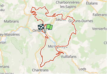

Longueur
53 km

Altitude max
662 m

Dénivelé positif
1331 m
Km-Effort
70 km

Altitude min
331 m

Dénivelé négatif
1331 m
Boucle
Oui
Date de création :
2018-04-16 22:36:30.632
Dernière modification :
2018-04-16 22:36:30.632
4h25
Difficulté : Très difficile

Application GPS de randonnée GRATUITE
 SityTrail
IGN / Instituts géographiques
SityTrail Plus
Le monde est à vous
À propos
Randonnée V.T.T. de 53 km à découvrir à Bourgogne-Franche-Comté, Doubs, Ornans. Cette randonnée est proposée par norbertmarteau.
Description
Saisie d'après plan, erreurs possibles !

Localisation
Pays :
France
Région :
Bourgogne-Franche-Comté
Département/Province :
Doubs
Commune :
Ornans
Localité :
Ornans
Départ:(Dec)
Départ:(UTM)
284651 ; 5220360 (32T) N.
Commentaires