Randonnée Geocaching Saint-Pierre-en-Auge - Les bois d'Ecots 3 - Photo
 yannick-p
yannick-p

Utilisateur

© OpenStreetMap contributors
Longueur
Longueur
6 km
Altitude max
Altitude max
182 m
Dénivelé positif
Dénivelé positif
143 m
Km-Effort
Km-Effort  
7,9 km
Altitude min
Altitude min
51 m
Dénivelé négatif
Dénivelé négatif
141 m
Boucle
Boucle
Oui
Date de création :
2018-04-17 10:01:19.838
Dernière modification :
2021-07-19 09:15:31.135

(0 Avis)

Geocaching
Geocaching
2h00
Difficulté : Moyen

Scannez ce code QR pour ouvrir la randonnée dans l'application SityTrail

Application GPS de randonnée GRATUITE

Logo SityTrail SityTrail

IGN / Instituts géographiques

Télécharger SityTrail sur l'App Store Télécharger SityTrail sur Google Play

Logo SityTrail SityTrail World

Le monde est à vous

Télécharger SityTrail sur l'App Store Télécharger SityTrail sur Google Play Télécharger SityTrail sur Huawei AppGallery

À propos

Randonnée Geocaching de 6 km à découvrir à Normandie, Calvados, Saint-Pierre-en-Auge. Cette randonnée est proposée par yannick-p.

Description

#13 Le bois d'Ecot / Sssss par  Django & Galaxie

https://coord.info/GC70EKN

Profil altimétrique

Localisation

Pays :
France
Région :
Normandie
Département/Province :
Calvados
Commune :
Saint-Pierre-en-Auge
Localité :
L'Oudon
Départ:(Dec)
Départ:(UTM)
282871 ; 5430449 (31U) N.

Randonnées à proximité

Randonnée Geocaching Saint-Pierre-en-Auge - Balade en campagne  - Photo
Geocaching
yannick-p

Geocaching

Facile
Saint-Pierre-en-Auge, Normandie, Calvados, France
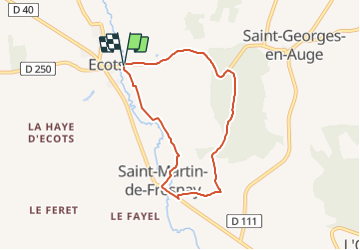
5,4 km | 6,6 km-effort
3h 20min
Oui
Randonnée Marche Saint-Pierre-en-Auge - Saint Georges en Auge - Photo
Marche
Roulland

Marche

Facile
Saint-Pierre-en-Auge, Normandie, Calvados, France
16,1 km | 21 km-effort
3h 33min
Oui
Randonnée Marche Saint-Pierre-en-Auge - Montviette - Photo
Marche
Roulland

Marche

Facile
Saint-Pierre-en-Auge, Normandie, Calvados, France
7,1 km | 8,3 km-effort
2h 7min
Oui
Randonnée Marche Livarot-Pays-d'Auge -  Traditional Cache #1 Fêtons nos 2000 !!! par nounou1437 - Photo
Marche
yannick-p

Marche

Moyen
Livarot-Pays-d'Auge, Normandie, Calvados, France
7 km | 8,8 km-effort
2h 0min
Oui
Randonnée A pied Saint-Pierre-en-Auge - Panorama sur l'Oudon - Photo
A pied
PRO

A pied

Facile
Saint-Pierre-en-Auge, Normandie, Calvados, France
12,7 km | 16,3 km-effort
3h 42min
Oui
Randonnée Geocaching Saint-Pierre-en-Auge - Géo-rando # 1 La petite vadrouille  - Photo
Geocaching
yannick-p

Geocaching

Moyen
Saint-Pierre-en-Auge, Normandie, Calvados, France
5,4 km | 6,8 km-effort
3h 30min
Oui
Randonnée Marche Saint-Pierre-en-Auge - St Marguerite de Viette - Photo
Marche
Eve - Line

Marche

Facile
Saint-Pierre-en-Auge, Normandie, Calvados, France
11 km | 13,1 km-effort
2h 47min
Oui
Randonnée Marche Saint-Pierre-en-Auge - Monviette - Photo
Marche
Roulland

Marche

Moyen
Saint-Pierre-en-Auge, Normandie, Calvados, France
22 km | 28 km-effort
5h 5min
Oui
Randonnée Marche Saint-Pierre-en-Auge - Vallée de l'Oudon - Photo
Marche
phi14

Marche

Facile
(1)
Saint-Pierre-en-Auge, Normandie, Calvados, France
12,9 km | 16,4 km-effort
3h 11min
Oui


Fermer
Mes abonnements