Randonnée Marche Lachapelle-aux-Pots - Lachapelle aux pots - Photo
 Marie-Claire-mcp
Marie-Claire-mcp

Utilisateur

© OpenStreetMap contributors
Longueur
Longueur
10,2 km
Altitude max
Altitude max
152 m
Dénivelé positif
Dénivelé positif
136 m
Km-Effort
Km-Effort  
12 km
Altitude min
Altitude min
84 m
Dénivelé négatif
Dénivelé négatif
136 m
Boucle
Boucle
Oui
Date de création :
2018-04-17 13:01:49.64
Dernière modification :
2018-04-17 13:01:49.64

(0 Avis)

Marche
Marche
2h37
Difficulté : Facile

Scannez ce code QR pour ouvrir la randonnée dans l'application SityTrail

Application GPS de randonnée GRATUITE

Logo SityTrail SityTrail

IGN / Instituts géographiques

Télécharger SityTrail sur l'App Store Télécharger SityTrail sur Google Play

Logo SityTrail SityTrail World

Le monde est à vous

Télécharger SityTrail sur l'App Store Télécharger SityTrail sur Google Play Télécharger SityTrail sur Huawei AppGallery

À propos

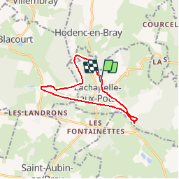
Randonnée Marche de 10,2 km à découvrir à Hauts-de-France, Oise, Lachapelle-aux-Pots. Cette randonnée est proposée par Marie-Claire-mcp.

Description

Lachapelle aux pots, rue de la Gare - Voie verte jusqu'à Vivier Danger - route à gauche puis chemin à gauche au virage jusqu'à Lachapelle aux pots (rue de la ferme)puis rue de Gerberoy - continuer dans le bois jusqu'au Rutoire - Traverser la route et au bout du chemin à gauche puis direction Blacourt à droite et à la route à droite puis La Boissière et chemin noir à gauche - La Fontaine Modet à gauche - puis Voie verte à gauche jusqu'à Lachapelle aux pots

Profil altimétrique

Localisation

Pays :
France
Région :
Hauts-de-France
Département/Province :
Oise
Commune :
Lachapelle-aux-Pots
Localité :
Unknown
Départ:(Dec)
Départ:(UTM)
420529 ; 5478156 (31U) N.

Randonnées à proximité

Randonnée V.T.T. Lachapelle-aux-Pots - la Chapelle aux Pots - Savignie - Photo
V.T.T.
sebcar

V.T.T.

Moyen
(1)
Lachapelle-aux-Pots, Hauts-de-France, Oise, France
19,1 km | 24 km-effort
1h 39min
Oui
Randonnée V.T.T. Pierrefitte-en-Beauvaisis - Grand tour - Photo
V.T.T.
jjeletufe

V.T.T.

(1)
Pierrefitte-en-Beauvaisis, Hauts-de-France, Oise, France
30 km | 35 km-effort
1h 44min
Oui
Randonnée Marche Senantes - Senantes - Photo
Marche
jpblimond

Marche

Moyen
Senantes, Hauts-de-France, Oise, France
18,7 km | 23 km-effort
4h 47min
Oui
Randonnée Marche Savignies - savignies - Photo
Marche
Novomarquiens

Marche

Facile
Savignies, Hauts-de-France, Oise, France
9,3 km | 12 km-effort
3h 0min
Oui
Randonnée Marche Lachapelle-aux-Pots - Lachapelle-aux-pots - Héricourt - La Frénoye - Armentières - Photo
Marche
Marie-Claire-mcp

Marche

Difficile
Lachapelle-aux-Pots, Hauts-de-France, Oise, France
10,7 km | 13,7 km-effort
3h 6min
Oui
Randonnée Marche Lachapelle-aux-Pots - Lachapelle aux pots - Armentières 11 km - Photo
Marche
Marie-Claire-mcp

Marche

Difficile
Lachapelle-aux-Pots, Hauts-de-France, Oise, France
10,6 km | 13,5 km-effort
3h 4min
Oui
Randonnée Marche Lachapelle-aux-Pots - Lachapelle aux Pots - Rando santé 1 - Photo
Marche
marcel.F

Marche

Moyen
Lachapelle-aux-Pots, Hauts-de-France, Oise, France
5,6 km | 6,4 km-effort
1h 24min
Oui
Randonnée Marche Lachapelle-aux-Pots - Lachapelle-aux-Pots - autour de la Crapaudière vers 2 - Photo
Marche
marcel.F

Marche

Facile
Lachapelle-aux-Pots, Hauts-de-France, Oise, France
9,9 km | 11,5 km-effort
2h 32min
Oui
Randonnée Marche Lachapelle-aux-Pots - Lachapelle-aux-Pots - autour de la Crapaudière - Photo
Marche
marcel.F

Marche

Facile
Lachapelle-aux-Pots, Hauts-de-France, Oise, France
9,4 km | 10,9 km-effort
2h 25min
Oui


Fermer
Mes abonnements