Randonnée Marche Athis-Mons - Orge 1 Athis - Epinay - Photo
 dmatignon
dmatignon

Utilisateur

© OpenStreetMap contributors
Longueur
Longueur
10,7 km
Altitude max
Altitude max
85 m
Dénivelé positif
Dénivelé positif
132 m
Km-Effort
Km-Effort  
12,4 km
Altitude min
Altitude min
32 m
Dénivelé négatif
Dénivelé négatif
120 m
Boucle
Boucle
Non
Date de création :
2018-04-17 15:00:19.362
Dernière modification :
2018-04-17 15:00:19.362

(0 Avis)

Marche
Marche
2h42
Difficulté : Facile

Scannez ce code QR pour ouvrir la randonnée dans l'application SityTrail

Application GPS de randonnée GRATUITE

Logo SityTrail SityTrail

IGN / Instituts géographiques

Télécharger SityTrail sur l'App Store Télécharger SityTrail sur Google Play

Logo SityTrail SityTrail World

Le monde est à vous

Télécharger SityTrail sur l'App Store Télécharger SityTrail sur Google Play Télécharger SityTrail sur Huawei AppGallery

À propos

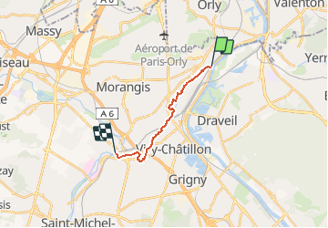
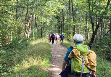
Randonnée Marche de 10,7 km à découvrir à Île-de-France, Essonne, Athis-Mons. Cette randonnée est proposée par dmatignon.

Description

En remontant l'Orge, de gare à gare, de son confluent avec la Seine jusqu'à Egly, en 3 étapes.

Profil altimétrique

Photos

Localisation

Pays :
France
Région :
Île-de-France
Département/Province :
Essonne
Commune :
Athis-Mons
Localité :
Unknown
Départ:(Dec)
Départ:(UTM)
456128 ; 5395656 (31U) N.

Randonnées à proximité

Randonnée Marche Juvisy-sur-Orge - GRP CV-IDF 16R Juvisy-sur-Orge à Ballainvilliers - Photo
Marche
clalaur

Marche

Difficile
(1)
Juvisy-sur-Orge, Île-de-France, Essonne, France
14,8 km | 17 km-effort
3h 52min
Non
Randonnée Marche Montgeron - J 38 Montgeron la Pelouse, forêt de Sénart - Photo
Marche

Marche

Moyen
(3)
Montgeron, Île-de-France, Essonne, France
12,3 km | 13,2 km-effort
3h 9min
Oui
Randonnée Marche Draveil - Port aux Cerises - Ablon 21 km - Photo
Marche
GUIDE
jeanmarcMasson

Marche

Très difficile
(1)
Draveil, Île-de-France, Essonne, France
22 km | 25 km-effort
4h 51min
Oui
Randonnée Marche Montgeron - 13767736-JVB 10 km - Photo
Marche
GUIDE
jeanmarcMasson

Marche

Moyen
(1)
Montgeron, Île-de-France, Essonne, France
10,3 km | 11,2 km-effort
2h 32min
Oui
Randonnée A pied Draveil - Port aux Cerises - Photo
A pied
Lucquiaud

A pied

Facile
(1)
Draveil, Île-de-France, Essonne, France
7,8 km | 8,5 km-effort
2h 32min
Oui
Randonnée V.T.T. Montgeron - Draveil foret de senart - Photo
V.T.T.
winshan

V.T.T.

Facile
Montgeron, Île-de-France, Essonne, France
7,3 km | 7,9 km-effort
59min
Non
Randonnée Marche Montgeron - Rando_Sénart_par_des_petits_chemins - Photo
Marche
GTarenne

Marche

Difficile
Montgeron, Île-de-France, Essonne, France
11,3 km | 12,2 km-effort
2h 48min
Oui
Randonnée Marche Montgeron - Parcouurs Sénart journée verte et bleue - Photo
Marche
chessyca

Marche

Très facile
Montgeron, Île-de-France, Essonne, France
16,1 km | 18 km-effort
3h 36min
Oui
Randonnée Marche Montgeron - Boucle Montgeron - Soisy - Draveil 22 km - Photo
Marche
chessyca

Marche

Très facile
Montgeron, Île-de-France, Essonne, France
22 km | 24 km-effort
5h 56min
Oui


Fermer
Mes abonnements