


2018_02_Circuit d'Anet

jeanlucien
Utilisateur
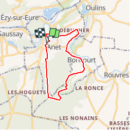

Longueur
11,1 km

Altitude max
139 m

Dénivelé positif
201 m
Km-Effort
13,8 km

Altitude min
65 m

Dénivelé négatif
199 m
Boucle
Oui
Date de création :
2018-04-17 17:34:58.753
Dernière modification :
2018-04-17 17:34:58.753
2h40
Difficulté : Facile

Application GPS de randonnée GRATUITE
 SityTrail
IGN / Instituts géographiques
SityTrail Plus
Le monde est à vous
À propos
Randonnée Marche de 11,1 km à découvrir à Centre-Val de Loire, Eure-et-Loir, Anet. Cette randonnée est proposée par jeanlucien.
Localisation
Pays :
France
Région :
Centre-Val de Loire
Département/Province :
Eure-et-Loir
Commune :
Anet
Localité :
Unknown
Départ:(Dec)
Départ:(UTM)
385467 ; 5412373 (31U) N.
Commentaires