


Calf Creek

raymondfn
Utilisateur
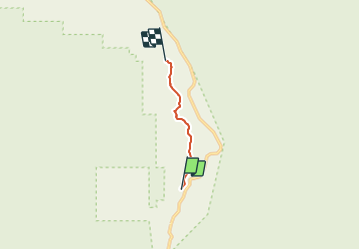

Longueur
4,7 km

Altitude max
1742 m

Dénivelé positif
182 m
Km-Effort
6,9 km

Altitude min
1632 m

Dénivelé négatif
107 m
Boucle
Non
Date de création :
2018-06-26 15:22:42.667
Dernière modification :
2018-06-26 15:22:42.667
1h46
Difficulté : Facile

Application GPS de randonnée GRATUITE
 SityTrail
IGN / Instituts géographiques
SityTrail Plus
Le monde est à vous
À propos
Randonnée Marche de 4,7 km à découvrir à Utah, Garfield County. Cette randonnée est proposée par raymondfn.
Description
A Capitol Reef
Localisation
Pays :
États-Unis
Région :
Utah
Département/Province :
Garfield County
Commune :
Calf Creek Recreation Area
Localité :
Unknown
Départ:(Dec)
Départ:(UTM)
463477 ; 4183038 (12S) N.
Commentaires