Randonnée Marche The Municipal District of Borris-in-Ossory — Mountmellick - Binninea Loop Cullahill - Photo
 mlmoroneybb
mlmoroneybb

Utilisateur

© OpenStreetMap contributors
Longueur
Longueur
10,2 km
Altitude max
Altitude max
269 m
Dénivelé positif
Dénivelé positif
245 m
Km-Effort
Km-Effort  
13,5 km
Altitude min
Altitude min
149 m
Dénivelé négatif
Dénivelé négatif
244 m
Boucle
Boucle
Oui
Date de création :
2014-12-10 00:00:00.0
Dernière modification :
2014-12-10 00:00:00.0

(0 Avis)

Marche
Marche
--
Difficulté : Moyen

Scannez ce code QR pour ouvrir la randonnée dans l'application SityTrail

Application GPS de randonnée GRATUITE

Logo SityTrail SityTrail

IGN / Instituts géographiques

Télécharger SityTrail sur l'App Store Télécharger SityTrail sur Google Play

Logo SityTrail SityTrail World

Le monde est à vous

Télécharger SityTrail sur l'App Store Télécharger SityTrail sur Google Play Télécharger SityTrail sur Huawei AppGallery

À propos

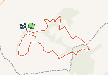
Randonnée Marche de 10,2 km à découvrir à Inconnu, County Laois, The Municipal District of Borris-in-Ossory — Mountmellick. Cette randonnée est proposée par mlmoroneybb.

Description

Starting from the mapboard at the car park 2Km from village, follow the purple arrow downhill for 200m to reach a pathway on your right. Follow this pathway uphill for 500m to reach a stile and exit the woodland.

Profil altimétrique

Localisation

Pays :
Irlande
Région :
Inconnu
Département/Province :
County Laois
Commune :
The Municipal District of Borris-in-Ossory — Mountmellick
Localité :
Cullahill ED
Départ:(Dec)
Départ:(UTM)
602962 ; 5851178 (29U) N.

Randonnées à proximité


Fermer
Mes abonnements