![](/images/other/stat-length.png)
![Percorso Mountainbike Ludres - Randonnée Sportive ludres - Photo](https://media.geolcdn.com/t/1900/400/ext.pjpeg?maxdim=2&url=https%3A%2F%2Fstatic1.geolcdn.com%2Fsiteimages%2Fupload%2Ffiles%2F1524743154velo.jpg)
Randonnée Sportive ludres
JJG54
Utente
![Lunghezza](/images/other/stat-length.png)
Lunghezza
10,7 km
![Altitudine massima](https://static1.geolcdn.com/siteimages/upload/files/1508320355ic_sort_altitude_max_24dp.png)
Altitudine massima
421 m
![Dislivello positivo](https://static1.geolcdn.com/siteimages/upload/files/1508320355ic_sort_den_pos_24dp.png)
Dislivello positivo
127 m
![Km-Effort](/images/other/stat-length.png)
Km-Effort
12,4 km
![Altitudine minima](https://static1.geolcdn.com/siteimages/upload/files/1508320355ic_sort_altitude_min_24dp.png)
Altitudine minima
372 m
![Dislivello negativo](https://static1.geolcdn.com/siteimages/upload/files/1508320355ic_sort_den_neg_24dp.png)
Dislivello negativo
124 m
![Boucle](https://static1.geolcdn.com/siteimages/upload/files/16400158638029165_repeat_loop_refresh_sync_direction_icon.png)
Boucle
Sì
Data di creazione :
2020-08-05 14:57:45.245
Ultima modifica :
2021-07-21 13:03:10.802
![Mountainbike](https://static1.geolcdn.com/sitytour/trail-icons/202.png)
51m
Difficoltà : Medio
![Scannerizza questo codice QR per aprire il percorso nell'applicazione SityTrail](https://capi.geolives.com/qq0zvz2zws4bq2lad0pu/sitytour/trails/2503476/qr.png?size=200)
Applicazione GPS da escursionismo GRATUITA
Chi siamo
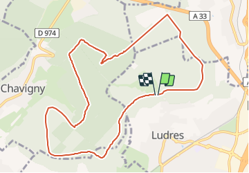
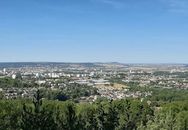
Percorso Mountainbike di 10,7 km da scoprire a Grande Est, Meurthe-et-Moselle, Ludres. Questo percorso è proposto da JJG54.
Descrizione
Randonnée sportive attention aux chemins ensablés au cause des terrassements pour le déboisement peuvent provoquer des chutes
Localizzazione
Paese:
France
Regione :
Grande Est
Dipartimento/Provincia :
Meurthe-et-Moselle
Comune :
Ludres
Località :
Unknown
Partenza:(Dec)
Partenza:(UTM)
290640 ; 5390026 (32U) N.
Commenti
Percorsi nelle vicinanze
![Percorso A piedi Fléville-devant-Nancy - Fléville-devant-Nancy et son château - Photo](https://media.geolcdn.com/t/375/260/ext.jpg?maxdim=2&url=https%3A%2F%2Fmedia.geolcdn.com%2Ff%2Fee7686de-cd52-43ca-b6f5-ed4c3a349bb0.jpeg)
![A piedi A piedi](https://static1.geolcdn.com/sitytour/trail-icons/100.png)
Fléville-devant-Nancy et son château
A piedi
Facile
Fléville-devant-Nancy,
Grande Est,
Meurthe-et-Moselle,
France
![](/images/other/stat-length.png)
7,9 km | 9,4 km-effort
2h 8min
![](https://static1.geolcdn.com/siteimages/upload/files/16400158638029165_repeat_loop_refresh_sync_direction_icon.png)
Sì
![Percorso Marcia Bainville-sur-Madon - Bainville sur Madon - Photo](https://media.geolcdn.com/t/375/260/ext.jpg?maxdim=2&url=https%3A%2F%2Fstatic1.geolcdn.com%2Fsiteimages%2Fupload%2Ffiles%2F1553511878bg_sport_marche.png)
![Marcia Marcia](https://static1.geolcdn.com/sitytour/trail-icons/101.png)
Bainville sur Madon
Marcia
Medio
(3)
Bainville-sur-Madon,
Grande Est,
Meurthe-et-Moselle,
France
![](/images/other/stat-length.png)
18,3 km | 23 km-effort
4h 15min
![](https://static1.geolcdn.com/siteimages/upload/files/16400158638029165_repeat_loop_refresh_sync_direction_icon.png)
Sì
![Percorso Marcia Vandœuvre-lès-Nancy - Randonnée USEP 2023 - Photo](https://media.geolcdn.com/t/375/260/ext.jpg?maxdim=2&url=https%3A%2F%2Fstatic1.geolcdn.com%2Fsiteimages%2Fupload%2Ffiles%2F1553511878bg_sport_marche.png)
![Marcia Marcia](https://static1.geolcdn.com/sitytour/trail-icons/101.png)
Randonnée USEP 2023
Marcia
Difficile
(1)
Vandœuvre-lès-Nancy,
Grande Est,
Meurthe-et-Moselle,
France
![](/images/other/stat-length.png)
11,7 km | 15,2 km-effort
3h 27min
![](https://static1.geolcdn.com/siteimages/upload/files/16400158638029165_repeat_loop_refresh_sync_direction_icon.png)
No
![Percorso Marcia Ludres - marche nuit - Photo](https://media.geolcdn.com/t/375/260/ext.jpg?maxdim=2&url=https%3A%2F%2Fmedia.geolcdn.com%2Ff%2F2c15af7e-0536-4068-be2b-216477912337.jpg)
![Marcia Marcia](https://static1.geolcdn.com/sitytour/trail-icons/101.png)
marche nuit
Marcia
Medio
Ludres,
Grande Est,
Meurthe-et-Moselle,
France
![](/images/other/stat-length.png)
8,7 km | 10,1 km-effort
2h 11min
![](https://static1.geolcdn.com/siteimages/upload/files/16400158638029165_repeat_loop_refresh_sync_direction_icon.png)
Sì
![Percorso Marcia Villers-lès-Nancy - RANDO DUO AVEC ALEXIS - Photo](https://media.geolcdn.com/t/375/260/ext.jpg?maxdim=2&url=https%3A%2F%2Fstatic1.geolcdn.com%2Fsiteimages%2Fupload%2Ffiles%2F1553511878bg_sport_marche.png)
![Marcia Marcia](https://static1.geolcdn.com/sitytour/trail-icons/101.png)
RANDO DUO AVEC ALEXIS
Marcia
Difficile
(1)
Villers-lès-Nancy,
Grande Est,
Meurthe-et-Moselle,
France
![](/images/other/stat-length.png)
38 km | 45 km-effort
10h 19min
![](https://static1.geolcdn.com/siteimages/upload/files/16400158638029165_repeat_loop_refresh_sync_direction_icon.png)
No
![Percorso A piedi Villers-lès-Nancy - Promenade d'Hardeval - Photo](https://media.geolcdn.com/t/375/260/ext.jpg?maxdim=2&url=https%3A%2F%2Fmedia.geolcdn.com%2Ff%2F43cb5da8-59dd-45f8-ae11-ca17f70000c7.jpeg)
![A piedi A piedi](https://static1.geolcdn.com/sitytour/trail-icons/100.png)
Promenade d'Hardeval
A piedi
Facile
Villers-lès-Nancy,
Grande Est,
Meurthe-et-Moselle,
France
![](/images/other/stat-length.png)
3,2 km | 4,3 km-effort
58min
![](https://static1.geolcdn.com/siteimages/upload/files/16400158638029165_repeat_loop_refresh_sync_direction_icon.png)
Sì
![Percorso Camminata nordica Ludres - Randonnée Ludres la mine la maison Patrick et Nini - Photo](https://media.geolcdn.com/t/375/260/ext.jpg?maxdim=2&url=https%3A%2F%2Fmedia.geolcdn.com%2Ff%2F2aa95365-fabd-4569-b6c7-48b029e99a55.jpg)
![Camminata nordica Camminata nordica](https://static1.geolcdn.com/sitytour/trail-icons/102.png)
Randonnée Ludres la mine la maison Patrick et Nini
Camminata nordica
Facile
Ludres,
Grande Est,
Meurthe-et-Moselle,
France
![](/images/other/stat-length.png)
6,7 km | 8,4 km-effort
1h 48min
![](https://static1.geolcdn.com/siteimages/upload/files/16400158638029165_repeat_loop_refresh_sync_direction_icon.png)
No
![Percorso Camminata nordica Ludres - Randonnée Ludres Belvédère - Photo](https://media.geolcdn.com/t/375/260/ext.jpg?maxdim=2&url=https%3A%2F%2Fmedia.geolcdn.com%2Ff%2Fe4a847d5-4f8b-43b2-8f0d-49e66642522d.jpg)
![Camminata nordica Camminata nordica](https://static1.geolcdn.com/sitytour/trail-icons/102.png)
Randonnée Ludres Belvédère
Camminata nordica
Facile
Ludres,
Grande Est,
Meurthe-et-Moselle,
France
![](/images/other/stat-length.png)
6,7 km | 8 km-effort
1h 44min
![](https://static1.geolcdn.com/siteimages/upload/files/16400158638029165_repeat_loop_refresh_sync_direction_icon.png)
Sì
![Percorso Marcia Bainville-sur-Madon - BAINVILLE SUR MADON - CIRCUIT VOIVRE ET JACQUES CALLOT - Photo](https://media.geolcdn.com/t/375/260/ext.jpg?maxdim=2&url=https%3A%2F%2Fmedia.geolcdn.com%2Ff%2F71b1e74d-91cb-4458-89e0-3ec0ae2fe5ca.jpg)
![Marcia Marcia](https://static1.geolcdn.com/sitytour/trail-icons/101.png)
BAINVILLE SUR MADON - CIRCUIT VOIVRE ET JACQUES CALLOT
Marcia
Medio
Bainville-sur-Madon,
Grande Est,
Meurthe-et-Moselle,
France
![](/images/other/stat-length.png)
19,8 km | 24 km-effort
5h 44min
![](https://static1.geolcdn.com/siteimages/upload/files/16400158638029165_repeat_loop_refresh_sync_direction_icon.png)
Sì